Bicester Vision 2040
5.1. In 2040, Bicester will continue to be a thriving historic market town and an important economic and social focus for its residents, visitors, and for business, achieving its Garden and Healthy New town objectives:
-
The town will have a diverse economic base with 50 hectares of land developed for new employment;
-
Over 10,000 homes will have been built by 2040 of which 30% will be affordable homes;
-
New services, facilities and cultural and recreation opportunities will have been provided;
-
The town will be healthier, with levels of deprivation reduced;
-
The town centre will be vibrant and at the heart of the town, a place to live, shop and access cultural and community facilities;
-
The quality of the public realm and built environment will have been improved and new developments will be designed to a high standard;
-
Air quality will have been improved and traffic congestion reduced;
-
There will be more opportunity for safe, convenient active travel routes and public transport will have been improved;
-
There will be more natural and semi-natural open space accessible to the public, including new wooded areas.
Bicester Policies
Core Policy 70: Bicester Area Strategy
5.2. To achieve this vision, our strategy for Bicester is as follows:
Overall Spatial Strategy
- Deliver committed development and be the focus for additional development reflecting the town’s on-going growth and transformation as a sustainable Garden Town and its regional and sub-regional location on the Oxford-Cambridge Corridor including and East-West Rail route;
- Continue to maximise the benefits of having key international and national destinations and economic activity to support further business investment;
- Support the continued improvement of the town’s centre, its facilities, its public realm and ‘green’ environment;
- Resolve transport connectivity and infrastructure challenges and encourage active travel.
Bicester Area Strategy
- Deliver new high quality development helping to achieve climate change objectives;
- Provide new jobs and services reducing the need for out-commuting and travel to other locations;
- Provide new infrastructure alongside new homes and employment;
- Maximise opportunities for new development on previously developed land within the existing urban area, particularly in the vicinity of the town centre;
- Bring about coordinated town centre improvements and regeneration including the redevelopment of Market Square;
- Support the role of the town centre by resisting further major out of centre retail developments;
- Ensure new developments deliver improved community and health facilities;
- Deliver an improved and enhanced green infrastructure network across the town, including access to green spaces, children’s play space, allotments, community gardens and a new cemetery;
- Protect and enhance areas of ecological importance and historic value;
- Deliver schemes that reduce transport congestion, including a potential new south east link road;
- Strengthen the connections between the town centre and Bicester Village;
- Ensure new developments deliver improved active travel routes in and around the town and to surrounding villages.
Question 31: What are your views on our aspirations for the Bicester area?
Housing
5.3. Bicester has been a key location for housing growth for the District for a number of years. Since 2011, there has been an additional 3,220 homes delivered at Bicester (at 31 March 2022), with 29% of the total houses built in the district at Bicester. Most of the new housing has been delivered on several large ‘strategic’ allocations on the edge of the town, including at Bure Park and South West Bicester.
5.4. In addition to the houses already built, as of 31 March 2022, there were permissions in place for a total of 4,268 additional homes at Bicester. These are primarily on sites allocated for housing in our last Local Plan.
5.5. In our last Local Plan, Bicester was identified as the location to receive the most amount of new development with over 10,000 homes across five strategic housing sites. There has been some progress made on these sites, however Banbury has shown stronger delivery with more of the allocated sites delivering in accordance with the Local Plan targets.
5.6. Fewer new homes have been built in the town centre and we are exploring opportunities for this. We will aim to do this through good design and catering for all those wishing to live in the town centre such as those who would prefer to live in the town centre in order to have easy access to services.
5.7. This Plan sets out a proposed distribution of new housing across the district and suggests two additional strategic housing sites at Bicester (see Bicester Area Strategy Map) These are:
i. South of Chesterton/North-West of A41;
ii. South-East of Wretchwick Green.
5.8. An extension to the existing site at North-West Bicester is also proposed providing for an additional 1,000 homes over that already identified.
5.9. It is proposed to retain other existing strategic housing site policies from the Local Plan 2011-2031.
Question 32: Do you think these sites in the Bicester area should be explored further for potential allocation for housing?
Question 33: Are there any alternative housing sites for Bicester you wish to suggest?
The Economy
5.10. Bicester supports a range of employment sectors, including service industries, distribution, defence, motorsports and manufacturing. The largest employment areas are located in the eastern and southern parts of the town. It has the second largest amount of employment floorspace in Cherwell after Banbury.
5.11. Bicester is identified in the Oxfordshire Local Industrial Strategy (2019) as a Living Labs Testbed. This involves a cluster of technology companies acting as ‘living labs’ to help develop technologies for environmental change, including the advent of connected and autonomous travel, all electric energy, smart homes and sustainable living.
5.12. The Oxfordshire LEP Investment Plan (2020) identifies potential for wider regeneration to transform Bicester from a traditional Oxfordshire County Market Town into a dynamic and vibrant economy drawing on attractions such as Bicester Village and Bicester Motion.
5.13. Our last Local Plan recognised the importance of Bicester to the local economy by:
- Allocating approximately 140 hectares of employment land;
- Encouraging green technology and the knowledge-based and logistics sectors, exploiting its position in the Oxford/Cambridge Corridor;
- Exploiting the towns transport connections;
- Utilising the Ex-MoD land;
- Creating new opportunities for additional retail, leisure and cultural activities in an extended town centre encouraging retailers and visitors to Bicester Town Centre;
- Continuing to promote and expand Bicester Village where complementary to improving the town centre;
- Improving its utilities infrastructure to improve its sustainability and self-sufficiency.
5.14. We have generally been successful in delivering our objectives from 2015. A significant proportion of the allocated employment land has now been developed and there continues to be strong interest for employment land at Bicester. Our updated employment evidence identifies that Bicester is the most suitable location for accommodating identified employment needs to 2040 and we propose to continue to focus new sites here.
5.15. This Local Plan proposes two new strategic sites for employment, at Junction 9 of the M40, and north of the A41 south east of Bicester. The policies for the existing sites identified in the 2015 Plan will be saved.
5.16. The site located adjacent to the M40 junction adjoins land which has recently gained planning consent for employment uses. The site north of the A41 is adjacent to Symmetry Park business park.
5.17. We will also need to consider the need for smaller, non-strategic employment sites to support local businesses and business start-ups.
Bicester Area Strategy Map

Core Policy 70: Bicester Area Strategy
Our over-arching priority for this area is to secure the aligned delivery of housing and infrastructure required to achieve sustainable development along with supporting the enhancement of the town centre.
Development in the Bicester Area should be in accordance with the Settlement Hierarchy set out in Core Policy 34.
Housing Delivery: 9,100 homes will be delivered at Bicester between 2020 and 2040 including the following strategic site allocations:
| Size | Housing Numbers 2020-2040 |
Housing Numbers Post 2040 |
|
| South of Chesterton / North West of A41 | 500 | - | New Site Allocation |
| South East of Wretchwick Green | 800 | - | New Site Allocation |
| North West Bicester | 2,775* | 4,000 | Extended Site Allocation to provide an additional 1000 homes replacing Policy Bicester 1 of the Local Plan 2011-2031 |
*225 completions recorded before 1/4/20
The following existing strategic site policies are retained and will not be replaced:
- Policy Bicester 2: Graven Hill
- Policy Bicester 3: SW Bicester
- Policy Bicester 12: SE Bicester
- Policy Bicester 13: Gavray Drive
A further allowance will be made for ‘windfalls’ of less than 10 dwellings on previously developed sites within the built-up area.
Employment: 49.6 hectares of employment land will be provided for business and employment growth in accordance with Core Policy 25 on the following strategic employment sites:
| Site | Employment Hectares |
| Land East of M40 J9 and South of Green Lane | 40.0 |
|
Land Adjacent to Symmetry Park, North of A41 South East Bicester |
6.3 |
| **Bicester 4 (Bicester Business Park) | 3.3 |
| Total | 49.6 |
** Bicester Business Park (Policy Bicester 4 in the 2015 Plan) is an existing allocation with residual capacity of 3.3ha beyond completions and extant planning permissions at 1st April 2022 that is being saved through this Local Plan.
Question 34: Do you agree with the employment sites we have selected at Bicester to accommodate new employment development?
Question 35: Are there any alternative sites to accommodate housing and employment needs that you think are more suitable?
Core Policy 71: Delivery of Strategic Transport Schemes within the Bicester Area
5.18. Bicester is located near to two motorway junctions on the M40 and has good transport links to Banbury, Oxford, London and beyond. It currently suffers from some congestion on its main routes, particularly on the A41, and on those that provide access to the town centre.
5.19. The new Oxfordshire Local Transport and Connectivity Plan (2022) identifies a number of key projects in the Bicester Area Strategy:
- An on-going partnership with Highways England to improve connectivity to the strategic highway (M40 junctions 9 and 10);
- Reviewing key county road links out of Bicester, including those that cross the county boundary (the A41) which is ongoing with Buckinghamshire Council;
- Investigating options for infrastructure improvements and bus priority to enable greater reliability on the A41 corridor to/from Junction 9 to the A41 Bicester Services roundabout, with schemes for accessing Wendlebury;
- Delivery of the bridge under the railway (A4095) as part of the project to deliver effective peripheral routes around the town;
- A41 Study exploring options for the provision of a South-East Perimeter Road;
- Working with the rail industry and the Department for Transport to develop a solution to the likely restrictions affecting the London Road as a result of the East-West Rail project and national rail programme;
- Ongoing work to improve Bicester’s bus services along key routes and providing improved public transport infrastructure;
- Continuing to enhance pedestrian, cycle and public transport links on key routes;
- Implementing Bicester town centre highway modifications on through routes in order to reduce through traffic in the town centre, constraining it to the peripheral routes and promoting more sustainable travel options in the town;
- Developing a coordinated parking strategy, including for electric vehicles, in partnership with Cherwell District Council.
5.20. Oxfordshire County Council has also produced the Bicester Local Cycling and Walking Infrastructure Plan (LCWIP; 2020) which includes a programme of measures to increase cycling and walking, and the Public Rights of Way Management Plan to 2025 which sets a strategy for the improvement and management of public rights of way in Oxfordshire.
5.21. The County Council’s Bus Service Improvement Plan (BSIP; 2021) proposes to create additional flexible bus services to connect rural communities with larger town centres and mobility hubs. New development at Bicester will be required to contribute towards the delivery of these routes and services.
5.22. The key challenges for Bicester’s transport network include:
- Addressing the barriers created by the peripheral roads that segregate the town centre from the new residential areas;
- Improving access to Bicester’s hinterland by active travel and public transport;
- Addressing capacity of the A41 and identifying a solution for the London Road Level crossing that enables access to and from the town centre;
- Deliver a better environment for walking and cycling in Bicester town centre including at Market Square and for sustainable travel;
- Improving the scope for and attractiveness of walking and cycling on Bicester’s key routes.
5.23. In order to deliver growth in the Bicester Area, transport infrastructure has been identified to mitigate the impact of planned growth that is important to help secure a viable and sustainable future for Bicester and the Bicester Area. The package may be further refined through development of the Local Transport and Connectivity Plan being developed by Oxfordshire County Council.
Core Policy 71: Delivery of Strategic Transport Schemes within the Bicester Area
All development within the Bicester area will be required to contribute in accordance with Core Policy 5: Providing Supporting Infrastructure and Services. Within the Bicester Area this will include contributions towards the infrastructure identified within the emerging Infrastructure Delivery Plan.
- A south-east link road north of Wendlebury;
- Improvements associated with London Road level crossing changes;
- A bus priority route adjacent to the A41, on the Banbury Road, and
- The realignment of Howes Lane.
Question 36: Are there any other transport schemes that you think should be delivered at Bicester?
Core Policy 72: Safeguarding of Land for Strategic Transport Schemes in the Bicester Area
5.24. We are proposing that Bicester accommodate a significant number of new homes and jobs to 2040. It is therefore important to secure highways improvements to accommodate this growth.
5.25. A south-east link road is identified in Oxfordshire County Council’s Bicester Area Strategy. The road will connect the two sections of the A41 north of the village of Wendlebury. The exact location and alignment of the road will be confirmed as this Plan progresses.
5.26. Careful consideration will need to be given to ecological constraints, historic assets, the crossing of the railway line, the relationship with employment land and potential impacts on Wendlebury. The link road will be designed to support active travel and include separate walking and cycling routes.
Core Policy 72: Safeguarding of Land for Strategic Transport Schemes in the Bicester Area
Land is safeguarded to support the delivery of the following identified transport schemes:
- Land for a south-east link road north of Wendlebury;
- A bus priority route adjacent to the A41, on the Banbury Road, and
- The realignment of Howes Lane.
Development will not be permitted should it prevent the use of land for the delivery and implementation of the identified schemes (Appendix 5).
Question 37: Are there any other areas of land that you think should be safeguarded for transport schemes at Bicester?
Core Policy 73: Delivery of Green and other Strategic Infrastructure in the Bicester Area
5.27. Bicester’s Garden Town status and its designation as a Healthy New Town emphasises the importance of protecting, expanding, and enhancing its green infrastructure networks.
5.28. Our last Local Plan sought to secure an urban edge park around the town. Other key open spaces include Bure Park, Pingle Fields and Bicester Fields. Garth Park is the main town park providing a mix of recreation provision. Local Wildlife Sites at Gavray Drive, Graven Hill and Bicester Wetland Reserve also form part of the town’s Green Infrastructure network, and the Ray Conservation Target Area incorporates the first of these sites in the south-east of the town. The new Burnehyll Community Woodland is being created to the south-west of the town.
5.29. We have published a Green Infrastructure Strategy alongside this plan that identifies a number of opportunities for Bicester to develop a successful green infrastructure network.
Open Space and Recreation Facilities
5.30. Our emerging Playing Pitch Strategy identifies shortfalls of provision to meet quantitative needs for football (both natural grass pitches and artificial grass pitches) and rugby union, and recommends qualitative improvements to grass pitches for all pitch sports and associated facilities.
5.31. Initial indications from the 2022 Built Facilities Study are that there is a requirement to continue to invest in indoor and built facilities in Cherwell and there is a need for new provision in the Bicester area in order to support expected population growth. This could take the form of an expansion of the existing leisure centre provision.
5.32. We will expect that all the strategic allocations at Bicester will provide for open space and recreation. There is potential for each of the strategic sites in Bicester to become specialist hubs for different types of sports facilities and recreation. The provision of open space and recreation facilities at strategic sites will be confirmed as the Local Plan progresses. Areas of existing open space in Bicester will continue to be protected.
Core Policy 73: Delivery of Green and other Strategic Infrastructure in the Bicester Area
All development will be required to protect and enhance green and blue infrastructure and assets in the Bicester area, as shown by maps in Appendix 6 and the Adopted Policies Map.
Contributions will be sought towards the strategic projects identified in the Cherwell Green and Blue Infrastructure Strategy for the Bicester area including their enhancement and on-going management costs, including:
- Establishing an urban edge park around the outskirts of the town, by protecting the existing network of green spaces and securing new open space and linear route provision linked with public footpaths/ cycleways, to create a circular route with connections to the town centre and the countryside beyond;
- Establishing a green corridor containing a community woodland between Vendee Drive and Chesterton;
- The restoration and use of Stratton Audley Quarry for informal outdoor recreation, provided that the proposals are compatible with the site’s designation as a Local Wildlife Site and partial SSSI;
- Extending and enhancing connections from residential areas to the town centre and outward from Bicester to and within; Ardley cutting and Quarry SSSI, Langford Meadows and Gavray wildlife meadows, Bignell Park and past the reservoir between Bicester and Chesterton, local nature sites surrounding Bicester Airfield, and to the south of Bicester;
- The greening of Sheep Street, Causeway and Church Street, Market Square, Garth Park, Bicester North Station, Bicester village station, and Bicester village;
- Re-naturalise and enhance Bicester’s river corridors and floodplains as multi-functional areas: including Langford Brook at Langford Meadows, through South Bicester and beyond the A41 and the River Bure and the floodplain around Bure Park, and
- The establishment of new burial grounds in Bicester.
Planning permission will not be granted for development that would prejudice the construction or effective operation of the schemes listed.
Question 38: Is there other green and blue infrastructure you think should be delivered at Bicester?
Bicester Town Centre and Areas of Change
5.33. Bicester has a small, historic town centre with a market and retail centre. In recent years there has been significant investment in Bicester including the opening of Pioneer Square with a new seven screen cinema, large supermarket, multi-storey car park, smaller retail outlets, and civic buildings including a library and a new hotel. However, in common with many high streets, the closure of some shops has resulted in vacancies and empty units. This has made some areas of the centre feel less vibrant and less attractive to visitors. We recognise that a successful and vibrant town centre is important to the local economy, and engenders local pride in the town.
5.34. Bicester Village is a premium designer shopping and tourist destination of regional, national, and international significance comprising over 170 units. It is a key economic driver within Cherwell and employs around 3,500 people directly and many others indirectly.
5.35. Our 2022 Retail Study identified a number of challenges and opportunities for Bicester town centre. It recommended further investment into its public realm and the quality of the environment, to create a more attractive and distinctive space.
5.36. It flagged the opportunity for increased leisure and eating-out venues, which could go some way to repurposing vacant shopping units and also noted that although Bicester Market is popular it does not perform to its full potential.
5.37. The Retail Study also noted the lack of connections between the town centre and Bicester Village which should be improved. There are also opportunities for the town centre to capitalise on the visitors brought to Bicester Village by offering an alternative and complementary experience.
5.38. The Retail Study concluded that there was an over provision of comparison retail floorspace in both Banbury and Bicester, and that overall there was no additional need for comparison or convenience floorspace across the district up to 2040. The study also concluded that any further out of centre expansion to Banbury or Bicester’s comparison fashion offer would be seriously detrimental to the vitality and viability of both town centres.
5.39. To ensure the long-term vitality and viability of Bicester town centre, we will apply a ‘town centre first’ approach to retail, services, and other main town centre uses. New retail development will continue to be focused in Bicester town centre and all new development will be required to be built to high design standards. We will resist further major out of centre retail development, due to the impact on the vitality and viability of Bicester town centre.
Core Policy 74: Bicester Areas of Change
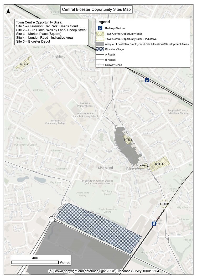
5.40. We have identified a number of opportunity areas have been identified within and close to Bicester Town Centre.
Site 1: Claremont Car Park/ Deans Court:
This site lends itself to residential use given its proximity to the Town Centre and existing housing areas.
Site 2: Bure Place/ Wesley Lane/Sheep Street:
This site provides an opportunity for sensitive remodelling to provide public realm and design improvements and could include new restaurants or space for leisure operators fronting Bure Place. Residential units on upper floors would help improve the attractiveness of this area and improve footfall, vibrancy and greater commercial returns for the leisure, food and beverage sector.
Site 3: Market Place (Square):
This area offers the opportunity to become a focal point of the Town Centre and a venue for periodic events that could drive interest and footfall in Bicester. Removal of car parking would facilitate improvements to the public realm, including widening of pavements, enable outside seating for the nearby food and beverage traders and create an attractive ‘café culture’ environment where visitors will want to spend more time.
Site 4: London Road Area:
The upgrades to East West Rail will necessitate the existing level crossing being closed for up to 50 minutes every hour and so there is an opportunity to provide positive change to the area which could include new parking and cycling and pedestrian links across the railway line.
Site 5: Bicester Council Depot:
The Council owns this site which is currently used for Council functions. The site is surrounded by residential development and there is a need for Council operations to locate to another site in Bicester. A site at Graven Hill has been identified. The existing site could be suitable for redevelopment for residential development.
Bicester Town Centre Areas of Change
Core Policy 74: Bicester Areas of Change
Five areas of change have been identified within or close to the centre of Bicester as listed below and shown on the Policies Map and Bicester Town Centre Areas of Change map, which are identified for specific change:
Site 1: Claremont Car Park/ Deans Court
Site 2: Bure Place/ Wesley Lane/Sheep Street
Site 3: Market Place (Square)
Site 4: London Road Area
Site 5: Bicester Depot
These areas are supported as locations for change and/ or redevelopment in accordance with the following criteria where development should:
i. Be of a high quality, with well-designed edges securing significant townscape improvements to Bicester and provide opportunities for the ‘greening’ of Bicester town centre;
ii. Proposals for the individual sites are prepared through a comprehensive masterplan process providing an integrated solution to site access, traffic management, air quality management, whilst prioritising the pedestrian/ customer environment;
iii. Be sensitive to any surrounding residential areas and the character and setting of the historic core and heritage assets and promote linkages to the historic core and wider town centre;
iv. Make a positive contribution to improving sustainable transport connectivity in Bicester, including an increase in capacity and the provision of improved facilities;
v. Be focused on providing access by sustainable modes of transport including improvements for pedestrians and cyclists such as managed cycle parking facilities, and with no increase in car parking above current levels;
vi. Improve the public realm, particularly in areas of historic value, such as Sheep Street and Market square, including by removing unnecessary signage and street furniture, and using a simple and durable palette of materials, and
vii. Residential development will be supported within proposals for the identified sites, particularly on above ground floors.
Masterplanning of Bicester town centre will be supported.
Question 39: Is there other green and blue infrastructure you think should be delivered at Bicester?
Question 40: Are there any other measures should we be taking to improve Bicester town centre?
Bicester’s Built Heritage
5.41. Bicester’s interesting and varied history is perhaps not as widely known or appreciated as other places in the district. The Roman settlement of Alchester scheduled monument lies to the southwest of the town. The remains of an Augustinian priory founded between 1182 and 1185 survive within the town centre which is largely Medieval in origin focused on Sheep Street, King’s End and the Causeway. Wretchwick deserted medieval settlement is in the south-east of the town. The historically important former RAF Bicester is now the home of Bicester Motion.
5.42. We have a duty to protect these important heritage assets. A key challenge for us is therefore to manage growth in a way that will not unacceptably harm the town’s important heritage assets and local distinctiveness.
Core Policy 75: Former RAF Bicester
5.43. The Former RAF Bicester is an inter-war airfield situated immediately to the north-east of Bicester. Historically it comprised a ‘Domestic Site’ and ‘Technical Site’ together with the large open space of the flying field. The whole of the site is a Conservation Area and most of the buildings and structures are protected by listing and scheduling. In addition, a Local Wildlife Site and proposed extension to the Local Wildlife Site covers a large part of the site.
5.44. We worked with the MOD and English Heritage and prepared a planning brief for the site in 2009. This brief recognised the complex issues, and the unique opportunities, raised by the site and the need to maintain and re-use its historic buildings and the flying field. The brief proposed a ‘conservation-led’ approach to the site, recognising that finding a use that can best preserve the sensitive historic fabric of the buildings may require a flexible approach in terms of the use to which the buildings are put.
5.45. Since then significant development has taken place at Bicester airfield providing new jobs and as a key destination for motorsport, new technologies, and events for historic car ownership, reflecting the sites history. A number of companies now occupy converted and new buildings in the south-eastern part of the site. We are keen to support the continued development, particularly as a tourist and leisure destination.
5.46. We wish to secure appropriate uses for a long-lasting ‘conservation-led’ approach to the technical site and flying field. Our aim is to establish uses that will be complementary to, and help enhance, the character and appearance of the conservation area and the nationally important heritage value of the site. We will encourage a mix of uses that will best preserve the sensitive historic fabric and layout of the buildings and the openness of the grass airfield.
Core Policy 75: Former RAF Bicester
Conservation-led proposals for the former RAF Bicester site will be encouraged that help to secure a long-lasting, economically viable future for the technical site and flying field.
Proposals for heritage tourism uses, leisure, recreation, employment and community uses will be particularly encouraged. The development of hotel and conference facilities will also be supported as part of a wider package of employment uses.
All proposals will be required to accord with the latest Conservation Area Appraisal for the site and the 2009 Planning Brief.
Any proposals for the former RAF Bicester site should demonstrate how they will maintain and enhance the character and appearance of the Conservation Area, protect listed, scheduled and other important buildings, their setting, and protect the sensitive historic fabric of the buildings and preserve the openness of the airfield. The biodiversity of the site should be protected and enhanced and habitats and species surveys (including a Great Crested Newt survey) should be undertaken.
The continuation of flying use will be supported at the site and opportunities for improving access to the countryside will also be encouraged.
Question 41: What are your views on our proposed approach to development at Former RAF Bicester?