Kidlington Vision 2040
6.1. In 2040 the Kidlington area will continue to be an attractive place to live, visit and invest:
- We will have delivered the 4,400 homes already planned to help Oxford’s unmet housing needs;
- Kidlington will be a local hub for employment and investment opportunities with attractive services and community facilities;
- Our residents and visitors will enjoy a high quality of life with improved access to natural green spaces and affordable housing;
- The area will be one of the best connected in Oxfordshire where people can and want to walk, cycle and use public transport.
Kidlington Policies
Core Policy 76: Kidlington Strategy
6.2. To achieve this vision, our strategy for the Kidlington area is to:
Overall Spatial Strategy
- Strengthen Kidlington’s role as a Local Service Centre;
- Continue to support investment in key economic assets including the Village Centre, London-Oxford Airport, Begbroke Science Park and at Langford Lane;
- Improve the built and ‘green’ environment of Kidlington Village Centre;
- Ensure the successful implementation of the committed 4,400 homes to help Oxford’s housing needs so that the planned benefits for the communities of Kidlington, Gosford and Water Eaton, Begbroke and Yarnton are delivered.
Kidlington Area Strategy
- Support a strong local economy with a focus on high value employment uses at Langford Lane and Begbroke centred on the Oxford Technology Park, London Oxford Airport and Begbroke Science Park;
- Deliver new planned neighbourhoods at Yarnton, Begbroke and Gosford and Water Eaton with community facilities and infrastructure supporting greener sustainable living;
- Support proposals that enhance the attractiveness and visibility of Kidlington’s centre;
- Promote an enhanced role for Kidlington as a local service centre with new business and homes in/near the village’s centre and an improved cultural and leisure/night economy offer;
- Improve access for all residents to high quality community facilities, sports and recreation spaces, and support improved health care facilities with the expansion of existing GP surgeries or a new facility;
- Securing high-quality well-designed and accessible buildings and public spaces;
- Provide enough market and affordable homes to address local needs;
- Protect and enhance the townscape and landscape that form the setting of Kidlington, Gosford and Water Eaton, Shipton on Cherwell and Thrupp, Begbroke and Yarnton and maintain their local distinctiveness;
- Protect and enhance areas of high natural capital value in the Cherwell Valley and the wider region including Oxford Meadows Special Area of Conservation (SAC) and the proposed Otmoor, Bernwood and Ray Nature Park;
- Support increased access to nature, open spaces and the Green Belt with specific opportunities to ‘green’ Kidlington’s centre and secure improvements to the Oxford Canal and River Cherwell corridors;
- Build on the area’s excellent links to Oxford, Bicester and London by public transport and work with County and Parish councils to deliver safe and inclusive routes that facilitate car free movements as the first choice for residents and visitors;
- Support the delivery of Kidlington’s Local Cycling and Walking Plan with new and enhanced walking and cycling routes linking Kidlington to the surrounding villages of Hampton Poyle, Islip, Yarnton, Begbroke, Thrupp, Shipton-on- Cherwell;
- Work with the Environment Agency, Thames Water and Oxfordshire County Council to mitigate surface water run off through appropriate sustainable drainage infrastructure and look for opportunities for betterment where flood risk is already present.
Question 42: What are your views on our aspirations for the Kidlington area?
Housing
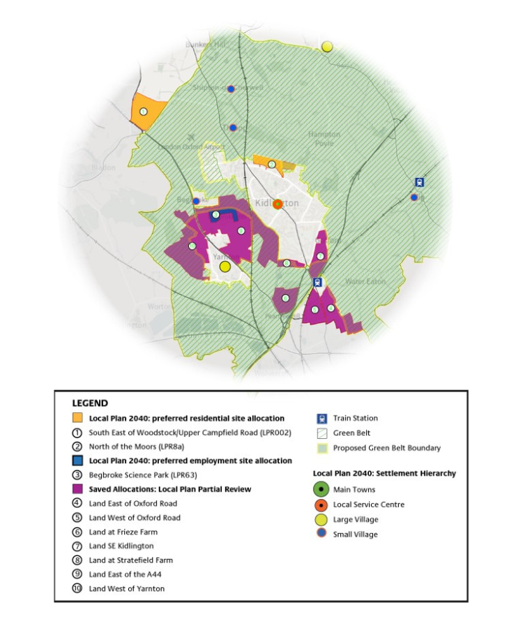
6.3. Over the next ten years some parts of the Kidlington area will see significant change, following the allocation of 4,400 new homes in the 2020 Partial Review of the Cherwell Local Plan. This is planned in six housing allocations located in the north of Oxford (PR6a and PR6b), Kidlington and southeast of Kidlington (PR7a and PR7b) and east and west of the A44 at Yarnton and Begbroke (PR8 and PR9).
6.4.We have prepared development briefs to help the delivery of these new neighbourhoods, guide their integration with the existing local communities and secure new schools and community facilities in the area.
6.5. In this Plan we need to consider the number and types of homes to support Kidlington’s need for market and affordable housing. Although we have a very significant level of housing already committed in the adopted Local Plans, no land has been identified for allocation to address local needs of the Kidlington area.
6.6. The 2015 Local Plan stated that housing requirements and the development strategy for Kidlington could be achieved “without the need for a strategic review of the Green Belt in the District”, and that “small scale affordable housing schemes to meet specifically identified local housing need may be met through the release of rural exception sites as part of the development control process, in accordance with Policy Villages 3”.
6.7. In the past twenty-three years, there have been fewer than 500 new homes built in Kidlington and we know this is one of the most expensive places to buy a home in Cherwell.
6.8. The area’s prosperity, good transport connections and proximity to Oxford are likely to explain higher property prices in this area. The recent increase on the subdivision of larger dwellings may be partly in response to this demand.
6.9. We consider Kidlington’s future important social and economic role is unlikely to be achieved by relying on a rural strategy and being dependent on rural exception sites coming forward.
6.10. Within the current affordability context and the limited number of homes made available in the past for local needs, we think there is scope to explore the allocation of housing on the edge of Kidlington to support affordable homes and balance the needs of the growing local economy.
6.11. The availability of land outside Kidlington’s urban area is constrained by the Oxford Green Belt. However, Kidlington is one of our most sustainable areas and we will need to weigh the importance of protecting the Green Belt with wider sustainability factors.
6.12. We have identified two sites for consideration: South-East of Woodstock and North of the Moors, the latter lying within the Oxford Green Belt.
i. South-East of Woodstock is well connected by sustainable transport modes to a wide range of employment, services and facilities in the area;
ii. North of the Moors is a sustainable site, well-connected to a wide range of existing local services and facilities, including public transport, but also makes limited contribution to the Green Belt purposes.
6.13. Both sites could contribute positively to supporting market and affordable housing in one of our most sustainable areas. Given their relatively large size, the sites could also help support much needed facilities and community infrastructure for existing and new residents.
6.14. We have prepared an illustrative map showing the extent of potential Green Belt review if North of the Moors was taken forward for allocation (Appendix 4).
Question 43: Do you think these sites in the Kidlington area should be explored further for potential allocation for housing?
Question 44: Are there any alternative housing sites for the Kidlington area you wish to suggest?
6.15. We are required to make as much use as possible of suitable brownfield and underutilised land before looking at countryside or Green Belt land. Before we can conclude that exceptional circumstances exist to justify changes to the Green Belt boundaries, we need to fully examine all other reasonable options.
6.16. Although we have not taken any formal views yet, we have followed up the 2017 Green Belt Site Study with an additional report. This is to understand the current context following the release of Green Belt land in the 2020 Local Plan Partial Review. Further work is being prepared.
6.17. We have identified opportunity areas within and near Kidlington’s centre for mixed-use development including housing, but to make sure we make best use of urban capacity we will explore further the availability and suitability of small-scale housing sites within Kidlington’s urban area before formally proposing land for allocation.
The Economy
6.18. Kidlington plays an important role in the wider economy of Cherwell. Its diverse economic base ranges from research and development to light industrial and commercial businesses and it has strong links with Oxford.
6.19. London Oxford Airport (Thames Valley area’s primary regional and business aviation airport), the University of Oxford’s Begbroke Science Park and the wider Langford Lane commercial area sit strategically in the Oxfordshire ‘knowledge spine’ halfway between Oxford and Bicester. Begbroke Science Park is an area identified in the Oxfordshire Local Industrial Strategy for further growth opportunities in advanced engineering and medical technology.
6.20. The 2011 Census travel to work data indicates there were c. 9,700 people living in Kidlington in employment and around 77% of those (8,100 people) were commuting to work. The majority of those commuting to work (44%) travelled to Oxford.
6.21. As ‘small area data’ is released from the 2021 Census we will gain a better understanding of how employment and travel to work patterns have changed in the area in the past decade. Nonetheless, we think there is an opportunity to improve the alignment of housing and employment in this area with its good connectivity to Oxford, Bicester and Oxford Parkway. This is likely to support further changes in commuting patterns aligned to sustainable transportation, especially to parts of Oxford and the District’s main towns of Bicester and Banbury.
6.22. Our last Local Plan (2015) identified the need for a small-scale Green Belt Review around the employment clusters formed by the London Oxford Airport and Langford Lane industrial area, and Begbroke Science Park to support high value employment needs.
6.23. A review undertaken in 2016 concluded Green Belt exceptional circumstances exist and land for area A was removed from the Green Belt in the 2020 Local Plan Partial Review following the Plan’s examination. At the time, it was noted that a new Technology Park had been granted permission in the Langford Lane area (area B) but that it would be for this emerging Plan to address the employment needs.
6.24. Since then, some 8 hectares of land were granted planning permission for a technology park at Langford Lane (currently under construction) and the 2020 Partial Review of the Local Plan reserved 14.7 hectares of land for the potential expansion of Begbroke Science Park. This Plan proposes the allocation of 14.7 hectares of additional employment land to support the expansion of Begbroke Science Park.
6.25. Begbroke Science Park hosts the Oxford University departments of Engineering Science and Materials, the Oxford Materials Characterisation Service and a large number of successful spin-outs and start-ups leading on research and technology. The proposed expansion will support Oxford University in transforming the science park into an Innovation District and deliver the Oxfordshire Local Industrial Strategy’s aspirations for the development of a major innovation quarter for UK and international collaboration and commercial research and development.
6.26. Retained Policy PR8 together with the allocation for the extension of Begbroke Science Park in this Plan will establish a highly sustainable and innovative urban neighbourhood with strong links to Kidlington Village Centre, to Oxford, and nearby communities of Yarnton and Begbroke.
6.27. A Development Brief for retained policy PR8 will guide the design principles for the delivery of the Science Park expansion and associated infrastructure and community facilities.
Question 45: Do you agree with the employment sites we have selected at Kidlington to accommodate new employment development?
Question 46: Are there any alternative sites to accommodate housing and employment needs that you think are more suitable?
6.28. Commercial development is already being delivered in the Technology Park at Langford Lane in recognition of the identified need in the 2015 Local Plan. A planning application for further commercial development at London Oxford Airport is currently pending determination.
6.29. We commissioned additional Green Belt evidence to help inform decisions on a small-scale review of the Green Belt in the Langford Lane area.
6.30. We consider there is a case to adjust the current Green Belt boundary on the southern side of Langford Lane to reflect the relationship between recently developed and open land following the development of the Oxford Technology Park.
6.31. We are also considering the appropriateness of adjustments to the Green Belt north of Langford Lane in and around the London Oxford Airport (LOA) area. However, this is far more complex. The distinction between the Business Park and functional airfield related development may preserve some contribution to safeguarding the countryside.
6.32. LOA benefits from permitted development rights for airport related development on the airport’s operational land. Core Policy 22 supports the continued use of LOA for commercial aviation and ancillary uses and guides proposals affecting the airport’s operations.
6.33. The airport is a regional centre for commercial aviation and training. There may be opportunities for research and technology business to be established at or near the airport, but we would like to ensure the airport has sufficient land for operational purposes now and in the future without placing undue pressure on the larger site area where the potential harm to Green Belt purposes may be greater.
6.34. We have prepared an illustrative map showing the extent of potential Green Belt adjustments (Appendix 4).
Question 47: Should this Plan adjust Green Belt boundaries in the Langford Lane area in response to recently developed land?
Question 48: Should land for employment use be identified at London Oxford Airport?
Kidlington Area Heritage
6.35. The heritage and history of Kidlington and surrounding villages is closely related to the setting of the River Cherwell, their proximity to Oxford and the 19th century developments of the Oxford Canal and railway.
6.36. The villages are predominantly inset within the Oxford Green Belt, which amongst other purposes, intends restraining development pressure which could affect the character of Oxford City and its heritage setting.
6.37. The Oxford Canal is a designated Conservation Area along its whole length, including through Kidlington. Many of the Canal bridges and locks are listed.
6.38. The 13th Century Grade I Listed Church of St Mary the Virgin is the focal point of the Church Street character area, prominent in views from across the flood meadows of the River Cherwell and forms an important view to the wider setting of Hampton Poyle Conservation Area north of the River Cherwell.
6.39. Begbroke’s Conservation Area, west of the A44 includes nine buildings and their grounds. The special character of the Conservation Area is the use of local materials in traditional styles within large maturely vegetated plots, bordered by dry stone walls. Care should be taken to ensure that the open parts of the Conservation Area and the land which make up its setting and impact positively on its appearance remain open.
6.40. In the wider setting, the World Heritage Site (WHS) of Blenheim Palace, registered park and associated setting on the southeast edge of Woodstock are of high significance. The setting of the Scheduled Ancient Monument, the ancient route of the ‘Ridgeway’ along the West Oxfordshire/Cherwell Boarder and the proximity of Bladon Conservation Area are also important heritage considerations.
6.41. The grounds of Blenheim Palace World Heritage Site (WHS) are situated to the east of the A44 in close proximity to London Oxford Airport that sits in the Oxford Green Belt. To the north of the airport and adjoining Woodstock’s boundary there are the buried remains of a Roman villa and associated fields, the designated Blenheim Villa Scheduled Ancient Monument (SAM).
6.42. North of Campsfield Road, existing woodland belts contain views of the approach to Woodstock and other wooded areas such as Campsfield Wood, in contrast with the openness of the landscape to the south.
Kidlington Area Strategy Map
Core Policy 76: Kidlington Area Strategy
Our over-arching priority for this area is to secure the aligned delivery of housing and employment together with the infrastructure required to achieve sustainable development.
Development in the Kidlington Area should be in accordance with the Settlement Hierarchy set out in Core Policy 34.
Housing Delivery: 900 homes will be delivered at Kidlington between 2020 and 2040 including the following strategic site allocations:
| Site |
Housing numbers |
|
| South-East of Woodstock | 450 | New Site Allocation |
| North of the Moors | 300 | New Site Allocation |
The following existing strategic site policies are retained and will not be replaced:
- Policy PR6a – Land East of Oxford Road
- Policy PR6b – Land West of Oxford Road
- Policy PR6c – Land at Frieze Farm
- Policy PR7a – Land South East of Kidlington
- Policy PR7b – Land at Stratfield Farm 1
- Policy PR8 – Land East of the A44
- Policy PR9 – Land West of Yarnton
A further allowance will be made for ‘windfalls’ of less than 10 dwellings on previously developed sites within the built-up area of Kidlington.
Employment: 14.7 hectares of employment land will be provided for business and employment growth on new strategic employment allocations as follows:
| Site | Employment Hectares |
| Begbroke Science Park - Expansion | 14.7 |
Core Policy 77: London-Oxford Airport
6.43. The London Oxford Airport (LOA) operates as a private airport and is the area’s primary regional and business aviation centre. LOA is the only commercial airport between Birmingham and London Heathrow and makes a significant contribution to the local and regional economy as a major infrastructure facility, local employer and supports the growing knowledge base and innovation sector in the area.
6.44. Current airport activities include general and business aviation uses, pilot training base (CAE Oxford Aviation Academy) and aircraft maintenance. Airbus Helicopters UK’s headquarters are based at the airport. Complementary activities include aerospace/aviation related industries and research and development.
6.45. Construction of a new c. 7,000m2 hangar with two bays including rear offices, stores and workshops commenced in 2021.
6.46. LOA intends to set a programme for the replacement of existing older hangars with new facilities. It will be important that the airport’s future and modernisation plans embrace all opportunities for carbon reduction, from the use of Sustainable Aviation Fuel (lifecycle carbon reduction of up to 80% compared to the traditional jet fuel) to more efficient aircraft design, and the development of future technologies like electrification.
6.47. LOA benefits from permitted development rights which in consultation with the Council could allow airport related development on the airport’s operational land. A section 106 agreement restricts the airport’s maximum annual operating capacity to 160,000 movements per year.
6.48. Support will be given to appropriate aviation related development proposals and the airport’s contribution to the local and regional economy. The Council will seek clear mitigation measures effectively addressing any aviation related environmental or health concerns.
6.49. Airport safeguarded areas refer to a designated zone of exclusion, in which the Aerodrome Operator can, in consultation with the Local Planning Authority, consult on development proposals to protect the environment surrounding the airport from development. Reasons for preventing development would include activities that have the potential to impact the aerodrome’s safe operation, or sensitive development that would likely be negatively and inappropriately impacted by the aerospace itself. Safeguarding ensures:
i. Buildings and structures in the area do not pose a danger to aircraft;
ii. The integrity of radar and other electronic aids to navigation are not affected;
iii. Inappropriate lighting is not present, to avoid confusion with aeronautical lighting;
iv. No increase in wildlife risk (e.g. bird strikes);
v. Operations that could create interference through construction processes are prevented;
vi. Aircraft are not impacted by potential ‘glint & glare’ from development (e.g. solar panels).
6.50. LOA’s safeguarded airspace measures two nautical miles (3.704km) in radius, centred around the Airfield Reference Point, the mid-point of the main instrument runway.
6.51. Airport related development within the safeguard area, and elsewhere, must be held to the same standards as other development, as set out within the supporting policies.
Aircraft noise
6.52. Aircraft noise is generally exempt from the general noise nuisance controls. The Department for Transport (DfT) is responsible for the control of aircraft noise. However, the Civil Aviation Authority indicates the overall policy is that noise issues are best handled at a local level by the airport and the relevant local authority, engaging with people who are affected by noise.
6.53. In order to determine whether or not any specific development is likely to increase ‘noise nuisance’ from aircraft, the Council will seek to assess the impact of that development in terms of:
i. The number, location, duration and frequency of aircraft activities or movements;
ii. The noise levels and sound frequencies (Hz) associated with individual aircraft activities or movements;
iii. The noise levels and sound frequencies (Hz) associated with overall aircraft activities or movements;
iv. Seasonality of aircraft activities or movements;
v. The time of day at which aircraft activities or movements take place.
Core Policy 77: London Oxford Airport
The Council will support the continued use of London Oxford Airport for commercial aviation and ancillary uses.
It will consult with the airport operator on proposals in the airport’s safeguarded areas, as shown by the Policies Map and Appendix 11. Development that may be a hazard to aircraft safety will not be permitted.
In consultation with the Airport Operator, the Council will ensure that:
i. Areas included in airport safeguarding areas are protected from development, and
ii. Sensitive uses such as housing, education and hospitals are not located in areas significantly affected by aircraft noise without acceptable mitigation measures.
Development proposals at the airport should include mitigation measures to address any environmental and health impacts, particularly in respect of noise, air quality, health, and climate change in compliance with other Development Plan policies.
Any proposals for development on the wider airport, that fall within the Oxford Green Belt, will need to comply with related Development Plan policies, including for development in the Green Belt.
Core Policy 78: Delivery of Strategic Transport within the Kidlington Area
6.54. The Kidlington area is one of the best connected in Oxfordshire. The Oxford Road/Banbury Road (A4260) and Woodstock Road (A44) link Kidlington and surrounding villages with Oxford City centre, Woodstock and the north of Cherwell. The A34, A40 and Oxford Parkway railway station provides easy access to Bicester, Oxford, London and the wider region.
6.55. Langford Lane and Upper Campsfield Road (A4095) to the north and Frieze Farm to the south are important east-west connecting routes between the A44 and A4260 corridors.
6.56. The A34 is a major strategic route carrying freight from Southampton to the Midlands. It crosses the western edge of Kidlington and Gosford as it runs from Bicester Junction 9 of the M40 to Peartree interchange north of Oxford.
6.57. The local road network suffers from congestion on its main routes, particular on the accesses to Oxford. The concentration of major road and rail intersections exacerbate congestion in this area.
6.58. Traffic congestion and the ability to travel between villages and main centres without the use of a car is a challenge. However, work with Oxfordshire County Council and other partners has secured well-served bus routes providing easy access to Oxford and Bicester and main employment areas, the construction of the Oxford Parkway railway station has improved rail connections to Bicester and London and further public transport improvements are under construction on the A44.
6.59. We know there is already a high level of cycling commuting in Kidlington and the walking and cycling proposals in the Kidlington LCWIP will extend safe active travel opportunities to rural areas by linking Kidlington to the villages of Hampton Poyle, Islip, Yarnton, Begbroke, Thrupp and Shipton-on- Cherwell.
6.60. Our 2020 Local Plan and the recently adopted Central Oxfordshire Travel Plan (November 2022) set out a clear strategy and infrastructure program for investing on public transport and active travel in the Kidlington area. Our focus on this Local Plan is to secure their delivery. We will make the most of the locational advantage and good public transport links in the area to support an ambitious shift to car-free travel.
6.61. It is important we bring together within this Plan transport and green infrastructure and deliver east-west active travel improvements across the Oxford Canal and the greening of Kidlington’s centre as covered by Core Policy 80.
6.62. The Water Eaton and Peartree Park and Ride sites on the boundary with Oxford provide approximately 1,800 car parking spaces between them. Their main function is the removal of private vehicles from the main corridors into Oxford to help reduce congestion.
6.63. In the 2020 Local Plan we indicated the location of a potential Park & Ride on the A44 within London Oxford Airport land to help reduce congestion on the A44 and the A4260 into Oxford and Kidlington.
6.64. Oxfordshire County Council are further exploring the future of Park & Rides and their potential to function as transport hubs and electric vehicle charging facilities. We will continue to discuss with the County Council any opportunities to reduce congestion in these corridors and propose to safeguard in principle land for this facility in Core Policy 78.
6.65. Transport infrastructure is not inappropriate development in the Green Belt. However, the type of facility and its design would need to preserve openness and not be in conflict with the purpose of including land within the Green Belt.
Core Policy 78: Delivery of Strategic Transport Schemes within the Kidlington Area
In order to deliver the growth in the Kidlington Area, transport infrastructure has been identified to mitigate the impact of planned growth that is important to help secure a viable and sustainable future for Kidlington and the Kidlington Area. The package may be further refined through development of the Local Transport and Connectivity Plan being developed by Oxfordshire County Council.
Transport infrastructure in the Kidlington area will be required as follows:
i. Improved bus services and facilities along:
a. The A44/A4144 corridor linking Woodstock and Oxford;
b. The A4260/A4165 (Oxford Road) linking Kidlington, Gosford, Water Eaton and Oxford;
c. Langford Lane, and
d. A44 P&R/ Transport Hub.
ii. The enhancement of the off-carriageway Cycle Track/ Shared Use Path along the western side of the A44 and the provision of at least one pedestrian and cycle and wheelchair crossing over the A44;
iii. The prioritisation of the A44 over the A4260 as the primary north-south through route for private motor vehicles into and out of Oxford;
iv. Improved rapid transit/bus services and associated Super Cycleway along the A4260 into Oxford;
v. Improvements to the public realm through the centre of Kidlington associated with (d) above;
vi. The provision of new and enhanced pedestrian, cycling and wheelchair routes into and out of Oxford, and
vii. The provision of the proposed cycle route network in Kidlington’s Local Cycling and Walking Implementation Plan (LCWIP).
All development within the Kidlington area will be required to contribute in accordance with Core Policy 51: Providing Supporting Infrastructure and Services. This will include contributions towards the infrastructure identified within the emerging Infrastructure Delivery Plan.
Question 49: Do you have any comments on the transport schemes proposed for the Kidlington area?
Core Policy 79: Safeguarding of Land for Strategic Highway
Improvements within the Kidlington Area
6.66. Our transport evidence to date lists the strategic transport improvements currently identified in the Local Transport Plan area strategies, and Oxfordshire’s Infrastructure Strategy for the Kidlington area. We will need to test the impact of our Local Plan proposals on the transport network and take a view in consultation with Oxfordshire County Council on whether the schemes should be delivered during the lifetime of this Plan. At this stage we are just highlighting their potential for safeguarding.
Core Policy 79: Safeguarding of Land for Strategic Transport Schemes in the Kidlington Area
Land is safeguarded to support the delivery of the following identified transport schemes:
- Improved bus services and facilities along the A44/A4260;
- A44 P&R/Transport Hub, and
- Proposed cycle and walking route network in Kidlington’s Local Cycling and Walking Implementation Plan (LCWIP).
Development will not be permitted should it prevent the use of land for the delivery and implementation of the identified schemes (Appendix 5).
Question 50: Are there any other areas of land that you think should be safeguarded for transport schemes in the Kidlington area?
Core Policy 80: Kidlington Green and Blue Infrastructure
6.67. The Kidlington area has a good range of community facilities. Recreational spaces and sports grounds at Orchard and Park Hill recreation grounds, Ron Groves, Exeter Close and Stratfield Brake provide green space, sports and play facilities serving the wider area alongside smaller green spaces and play parks.
6.68. Six primary schools at Kidlington, Gosford and Yarnton, a secondary school at Gosford Hill and further planned primary and secondary schools at Begbroke and Water Eaton will serve current and future education needs.
6.69. The Integrated Care Board, local GP practices and parish and district councils have explored opportunities for new health care facilities to extend the patient capacity of the two GP practices. Exeter Hall has been the preferred location for a health hub for some time but with the local GP practices already at capacity, other opportunities including increasing capacity at Yarnton may need to be secured if feasibility work undertaken by the Parish Council shows Exeter Hall cannot accommodate a health centre expansion.
6.70. Evidence supporting the 2015 Local Plan and the 2016 Kidlington Master Plan indicated a shortage of parks and gardens, allotments and playing pitches in the area.
6.71. Our 2020 Local Plan addressed this shortage with new natural and seminatural open spaces, recreational areas and formal sports provision including c. 4 hectares of land for strategic sports provision south-east of Kidlington complementing key sports facilities at neighbouring Stratfield Brake.
6.72. We will deliver this commitment and set up new policies in the emerging Plan seeking the protection of existing and planned facilities and setting standards for new provision through new development.
6.73. The leisure centre at Gosford and health & fitness offer at Langford Lane provide for indoor sports facilities but further facilities will be required to 2040. The planned secondary school at Begbroke is expected to offer shared use of a new four-court sports hall and the swimming facilities at Kidlington and Gosford Leisure Centre will require expansion.
6.74. The 2020 Local Plan Partial Review addressed some of the green Infrastructure and recreational open space opportunities along the canal identified in the 2016 Master Plan and provides for additional facilities in the area including the need for new and improved community and strategic infrastructure including education, health, sports and community facilities is being considered through the preparation of an Infrastructure Delivery Plan (IDP) that accompanies this Plan to ensure facilities are secured from new development.
6.75. The River Cherwell and Oxford Canal are important green infrastructure corridors for biodiversity and active travel connecting Kidlington towards Oxford and gives access to the wider countryside beyond. Open spaces and areas of high natural and landscape value stretch along the river and canal lengths and frame the setting of Kidlington, surrounding villages and that of Oxford. The area includes open spaces such as the woodland and wetland habitats at Stratfield Brake, Begbroke Wood Local Wildlife Site and Rushy Meadows Site of Special Scientific Interest as well as the open spaces in the Lower Cherwell Conservation Target Area. All of which contribute to Oxfordshire’s nature recovery network.
6.76. The Cherwell Green and Blue Infrastructure Strategy 2022 has been prepared to ensure we, our partners and local community, have a framework which supports increased access to nature, open space and the Green Belt, help us conserve our heritage, landscape and natural environment, makes us more resilient to climate change and support active travel.
6.77. In the Kidlington Area, the strategy addresses the network of green spaces and routes, landscape and water features shaped by the canal and River Cherwell as well as the greening of Kidlington’s urban area. The strategy identifies area specific opportunities and sets projects for the protection of green spaces and increased wider benefits to people and biodiversity. Importantly, it sets the area in a wider natural context with links to important spaces within the Oxford Meadows and Farmoor conservation target area and the Oxford Meadows Special Area of Conservation further south.
6.78. Priorities to 2040 include:
- Protecting the function of the river Cherwell floodplain;
- Protecting areas of green space of high natural capital and nature recovery value surrounding Kidlington and surrounding villages set within the two conservation target areas: Lower Cherwell Valley CTA and Oxford Meadows and Farmoor CTA;
- Improving blue corridor connectivity along the canal and river corridors;
- Supporting active travel through integrated green infrastructure to help reduce daily commutes to Oxford;
- Supporting improvements to the River Cherwell’s water quality.
Core Policy 80: Kidlington Green and Blue Infrastructure
The Council will require all development proposals to protect and enhance green and blue infrastructure and assets in the Kidlington area as shown by maps in Appendix 6 and the Adopted Policies Map.
The Council will seek contributions towards the strategic projects identified in the Cherwell Green and Blue Infrastructure Strategy for the Kidlington area including their enhancement and on-going management costs, including:
i. Expanding and enhancing Kidlington’s network of footpaths and trails;
ii. Enhancing the Oxford Canal and River Cherwell blue corridors;
iii. New and enhanced access to the canal and river, and
iv. Greening Kidlington village centre and supporting walking and cycling.
Planning permission will not be granted for development that would prejudice the construction or effective operation of the schemes listed.
Question 51: Do you have any comments on the green and blue infrastructure proposed for the Kidlington area?
Core Policy 81: Kidlington Areas of Change
6.79. In the past ten years, recent retail/town centre developments, with office and residential uses above and public realm improvements, have helped consolidate the village centre. Today, the centre has a strong service offer and very low vacancy rates.
6.80. Looking to 2040, investing in village centre spaces and improving their accessibility and visibility will be key to support Kidlington’s role as a local service centre.
6.81. The recent completion of a 100-room hotel at Langford Lane has helped increase the accommodation offer in the area. Enhancements to the Oxford Canal and River Cherwell corridors and a focus on strengthening the village centre and public realm will increase opportunities for leisure activities and improve the attractiveness of the area as a destination.
6.82. Our Retail and Town Centre Study made specific recommendations for the village centre and its spaces including:
i. Prioritise improvements to the public realm and arrival experience to the centre:
- Improve the attractiveness of the Banbury Road/Oxford Road approach to the village centre to enhance arrival experience;
- Provide of a gateway to the village centre;
- Increase the visibility Kidlington Centre as a whole and Kidlington Centre arcade including further signage, and
- Improvements to make the west of High Street/Watts Way area a focal point and increase its use.
ii. Encourage clustering of evening economy/leisure uses for example around the pedestrianised square (west of High Street/Watts Way);
iii. Improve the availability of private & affordable housing and senior living in the village centre;
iv. The village centre boundary should broadly reflect the existing boundary except for a residential dwelling to the west of the Black Bull Public House which is recommended to be removed, and
v. Drawing a compact Primary Shopping Area.
6.83. Our latest evidence indicates we should be directing retail development to the Primary Shopping Area only and leisure uses to the village centre as a whole. This is to avoid overprovision of retail floorspace and support stronger relationships and connections between retail uses.
6.84. We propose a minor amendment to the village centre boundary and a primary shopping area.
6.85. Saved Policies PR6a and PR8 will enable the provision of a small-scale neighbourhood centre at Gosford and Water Eaton in proximity to the Oxford Parkway and at Yarnton on the east side of the A44 to support existing and planned communities in the area.
Question 52: Do you have any views on the proposed changes to the village centre?
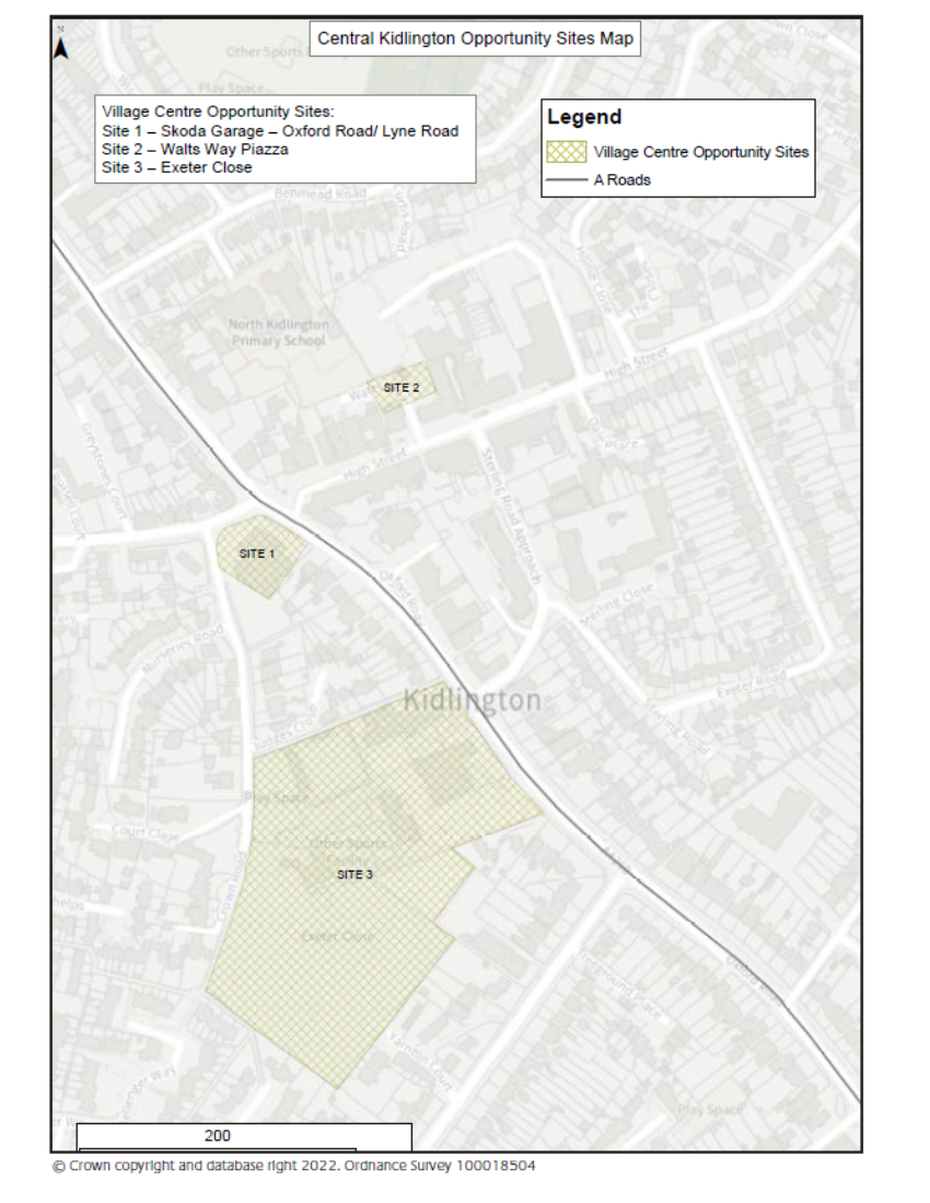
6.86. The Town Centre and Retail Study identifies two sites with regeneration opportunities within and close to Kidlington village centre:
Site 1: Skoda Garage, Oxford Road/Lyne Road
Site 2: Watts Way Piazza.
6.87. Further technical and feasibility work will need to be carried out to understand the potential of these opportunity areas, but the sites are considered important to improve the visibility and attractiveness of the village centre and secure public realm enhancements. Any future proposals should not preclude the delivery of these village centre improvement opportunities.
6.88. The 2016 Kidlington Framework Master Plan identified a number of other sites with regeneration potential, the Co-op car park has now been completed but Exeter Close has property constraints which affect the consideration of development proposals.
6.89. Exeter Close is an important civic space in the vicinity of the village centre with uses including a community hall, medical practice, recreational open space and sports provision.
6.90. We are proposing a criteria-based policy to guide the development of sites 1 and 2 and have also included Exeter Close. We are committed to continue working with partners to deliver this site if an appropriate development proposal comes forward.
Kidlington Town Centre Areas of Change
Core Policy 81: Kidlington Areas of Change
Three principal areas of change have been identified within or close to the centre of Kidlington as listed below and shown on the Policies Map and Kidlington Town Centre Areas of Change map:
Site 1: Skoda Garage – Oxford Road/ Lyne Road
Site 2: Watts Way Piazza
Site 3: Exeter Close
These areas are supported as locations for change and/ or redevelopment in accordance with the following criteria where development should:
i. Be of a high quality, with well-designed edges securing significant townscape improvements to Kidlington;
ii. Proposals for the individual sites are prepared through a comprehensive masterplan process providing an integrated solution to site access, traffic management, air quality management, whilst prioritising the pedestrian/ customer environment;
iii. Be sensitive to any surrounding residential areas and the character and setting of the historic core and heritage assets and promote linkages to the village centre;
iv. Make a positive contribution to improving sustainable transport connectivity in Kidlington, including an increase in capacity and the provision of improved facilities;
v. Be focused on providing access by sustainable modes of transport including improvements for pedestrians and cyclists such as managed cycle parking facilities, and with no increase in car parking above current levels, and
vi. Improve the public realm and by removing unnecessary signage and street furniture, and using a simple and durable palette of materials.
Residential development will be supported within proposals for the identified sites, particularly above ground floors.
Question 53: Do you have any views on the areas of change identified?
Question 54: Are there any other opportunity areas or sites that we should be including?