Cherwell Local Plan Review 2040
Banbury Vision 2040
4.1. In 2040 Banbury will continue to be a thriving, historic market town and an important economic and social focus for its residents, visitors, for business and for a large rural hinterland.
- The town will have a diverse economic base;
- Over 5,000 homes will have been built by 2040 of which 30% will be affordable homes;
- New services, facilities and cultural and recreation opportunities will have been provided;
- The town will be healthier, with levels of deprivation reduced;
- The town centre will be vibrant and at the heart of the town, a place to live, shop and access cultural and community facilities;
- The quality of the public realm and built environment will have been improved and new developments will be designed to a high standard;
- Air quality will have been improved and traffic congestion reduced;
- There will be more opportunities for safe, convenient active travel routes. Public transport will have been improved;
- There will be more natural and semi-natural open space accessible to the public, including new wooded areas and new linear parks/green corridors.
Banbury Policies
Core Policy 62: Banbury Strategy
4.2. To achieve this vision, our strategy for Banbury is as follows:
Overall Spatial Strategy
- Deliver committed development and provide for some limited additional growth reflecting the topographical, landscape and rural character constraints of the town’s edge;
- Revitalise, appropriately repurpose and seek further investment in the town centre, continue to improve its built and ‘green’ environment and public realm and further develop the nighttime economy;
- Continue to support and strengthen the town’s economy and diversify its skill base;
- Encourage development proposals that will support education and help reduce deprivation;
- Seek strategic transport improvements to encourage active travel, reduce congestion and pollution, and reduce cross town traffic by motorised vehicles.
Banbury Area Strategy
- Focus new development on previously developed land within the existing urban area, particularly in the vicinity of the town centre;
- Bring about Canalside regeneration, including enhancing the gateway to the town and improving access to the railway station, for the benefit of the whole town;
- Encourage residential development within the town centre on appropriate sites;
- Support the role of the town centre by resisting further major out of centre retail developments;
- Help reduce the level of deprivation by securing benefits achieved through specific development proposals and by economic growth and diversification;
- Secure a site that will provide a permanent home for Banbury United Football Club;
- Deliver a new secondary school for the town;
- Ensure new developments deliver improved community and health facilities;
- Deliver an improved and enhanced green infrastructure network across the town, including access to green spaces, the Oxford Canal and River Cherwell corridor, and children’s play space, allotments and community gardens;
- Deliver schemes that reduce transport congestion, particularly along Hennef Way and in areas around the town centre;
- Ensure new developments strengthen the connection between the town centre and railway station, a key gateway to the town, and
- Ensure new developments deliver improved active travel routes in and around the town, radiating to surrounding villages.
Question 27: What are your views on our aspirations for the Banbury area?
Housing
4.3. Since 2011, there has been an additional 4,123 homes delivered at Banbury (at 31 March 2022), with over a third (43%) of the total completions for the district at Banbury. Most of the new housing has been delivered on several large ‘strategic’ allocations on the edge the town, these include Hanwell Fields, to the north-west, and Longford Park in the south.
4.4. In addition to the houses already built, as of 31 March 2022, there were permissions (either outline or full) for a total of 2,341 additional homes at Banbury. These are primarily on sites allocated for housing in our last local plan. Many of these sites have been built, or are currently under construction.
4.5. In our 2015 Local Plan, less development was identified at Banbury compared to Bicester. Banbury has delivered more of its allocated sites but has not had the same strategic infrastructure challenges as Bicester.
4.6. Recent residential developments in the town centre have provided high quality accessible and affordable housing for those wishing to live in the town centre. It will be important that residential development in the town centre supports the growth of the town centre economy and complements surrounding areas. It should do this through good design and catering for all those wishing to live in the town centre such as down sizers, those that don’t rely on access to a car and those who would prefer to live in the town centre in order to have easy access to services.
4.7. Within this context we think that there is scope for two additional housing allocations on the edge of the town: at Withycombe Farm, and north of Wykham Lane. We are also carrying out further work to understand the capacity for new housing development within the town, particularly within the town centre.
Question 28: Do you think these sites in the Banbury area should be explored further for potential allocation for housing?
Question 29: Are there any alternative housing sites for Banbury you wish to suggest?
The Economy
4.8. Banbury’s economy is focused on manufacturing, distribution, service industries, local government, and health. The Oxfordshire Local Industrial Strategy identifies the town as an important industrial area for motorsport, building on its links to Silverstone Park in neighbouring Northamptonshire.
4.9. The economy of the town benefits from its location on the M40, and its excellent transport links to Oxford, the South-East, and the Midlands. It also benefits from having the most employment floorspace in Cherwell.
4.10. Our last Local Plan (2015) recognised the importance of Banbury to the local economy by:
- Allocating approximately 60 hectares of employment land, most of which has now been developed;
- Promoting the town as an important location for higher technology and knowledge-based industries;
- Encouraging high-end manufacturing;
- Maintaining an increase in motorsport industries;
- Encouraging retailing and commercial leisure development;
- Encouraging higher value distribution companies, and
- Maximising the town’s location and transport links.
4.11. The subsequent 2016 Banbury Masterplan embraced these aims and highlighted how, by driving the engineering economy and investing in
infrastructure and skills, economic growth could be achieved.
4.12. We have generally been successful in delivering our objectives from 2015. Most of the allocated employment land has now been developed and there continues to be strong interest for employment land in or adjacent to the
town. Much of this new development has been in the form of large logistics warehousing, but our evidence indicates that there is a strong unmet demand for smaller employment units to meet the needs of start-up firms, local businesses, or those that wish to expand in the local area.
4.13. To meet this identified need we are supporting a number of existing employment sites at Banbury where there is considerable potential for redevelopment. As we work towards our final plan we will be gathering more evidence to identify and support opportunities for smaller, non-strategic, employment sites.
Banbury Area Strategy Map
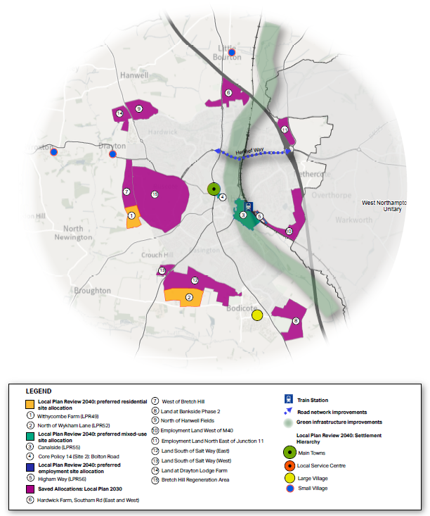
Core Policy 62: Banbury Area Strategy
Our over-arching priority for this area is to secure the aligned delivery of housing and infrastructure required to achieve sustainable development and support town centre regeneration.
Development in the Banbury Area should be in accordance with the Settlement Hierarchy set out in Core Policy 35:
Housing Delivery: 5,950 homes will be delivered at Banbury between 2020 and 2040 including the following strategic site allocations:
| Site | Housing numbers 2020 - 2040 | |
| North of Wykham Lane | 600 | New Site Allocation |
| Withycombe Farm | 230 | New Site Allocation |
| Canalside | -168 | Replacing Policy Banbury 1 of the Local Plan 2011-2031 with a new allocation including 500 homes |
| Higham Way | -150 | Replacing Policy Banbury 19 of the Local Plan 2011-2031 to allow for employment use |
The following existing strategic site policies are retained and will not be replaced:
- Policy Banbury 2: Land to the West of Southam Road
- Policy Banbury 3: West of Bretch Hill
- Policy Banbury 4: Bankside Phase 2
- Banbury 5: North of Hanwell Fields
- Banbury 16: South of Salt Way West
- Banbury 17: South of Salt Way East
- Banbury 18: Land at Drayton Lodge Farm
A further allowance will be made for ‘windfalls’ of less than 10 dwellings on previously developed sites within the built-up area.
Employment: 10.5 hectares of employment land will be provided for business and employment growth in accordance with Core Policy 25 in the following locations:
| Site | Employment Hectares |
| Higham Way | 3.0 |
| Canalside – Regeneration | 7.5 |
| Total | 10.5 |
Core Policy 63: Delivery of Strategic Transport Schemes within the Banbury Area
4.14. We need to focus on supporting sustainable connectivity and ensuring new development is located where opportunities for sustainable development and transport can be maximised. Traffic congestion is an issue in Banbury, and so it is important that this Plan minimises and mitigates against additional traffic, and supports development where sustainable transportation and active travel can be utilised to the maximum extent.
4.15. The town’s environmental and physical constraints, together with the canal, river and railway line running north-south through the town, make the delivery of a new strategic road network both challenging and costly. New and innovative solutions will be needed, and this work is being led by the County Council through the preparation of updated Area Travel Plans to support the recently adopted Local Connectivity Transport Plan Update (2022).
4.16. The current transport strategy is based on the need to improve connectivity to and from residential areas, employment locations and the town centre. The aim is to deliver infrastructure improvements to promote sustainable travel in and around the town by bus, walking, and cycling, and to increase capacity on the road network.
4.17. There has been investment in electric vehicle charging points in recent years and the take up of ultra-low emission vehicles in Banbury is significantly higher than the national average. Furthermore, Banbury also benefits from the highest share of active travel (23%) in the Oxfordshire towns.
4.18. However, there are still significant transport related issues that we need to address. These include:
- Transport and transport congestion, particularly along Hennef Way and in areas around the town centre;
- Limited options for a new strategic route between the east and west of the town;
- The need to strengthen the connection between the town centre and railway station;
- The need to refurbish or relocate Banbury Bus Station;
- The need for further improvements to bus services and access into and across the town centre, and
- The continued improvement of cycling and walking routes radiating from the town centre to satellite settlements encouraging the adoption of alternative transport methods and easing the existing pressure on the road infrastructure.
4.19. In order to deliver growth in the Banbury Area, highways infrastructure has been identified to mitigate the impact of planned growth that is important to help secure a viable and sustainable future for Banbury and the Banbury Area. The package may be further refined through the development of the Local Transport and Connectivity Plan being developed by Oxfordshire County Council.
Core Policy 63: Delivery of Strategic Transport Schemes within the Banbury Area
Transport infrastructure at Banbury will be required as follows:
- New M40 junction/ enlarged slip roads at Southam Road in Banbury;
- Rejuvenating or relocating Banbury Bus Station;
- Re-designing Banbury Station forecourt to improve multi-modal interchange;
- Improving capacity of north south routes: Cherwell Street/ Bridge Street/A4620 Windsor Street corridor;
- East-west strategic movements: Hennef Way corridor A422 Improvements;
- East-west strategic movements: Warwick Road Corridor Improvements;
- Review of Banbury Town Centre traffic circulation;
- Car parking routing and guidance system;
- Potential link road crossing from Tramway to Higham Way or a South East Link Road Promotion of Bankside to include bus services, and
- New spine road and increased level of bus service – east of Bloxham Road.
Core Policy 64: Safeguarding of Land for Strategic Transport Schemes in the Banbury Area
4.20. Our transport evidence to date lists the strategic transport improvements currently identified in the Local Transport Plan area strategies, and Oxfordshire’s Infrastructure Strategy for the Banbury area. We will need to test the impact of our Local Plan proposals on the transport network and take a view in consultation with Oxfordshire County Council on whether the schemes should be delivered during the lifetime of this Plan. At this stage we are just highlighting their potential for safeguarding.
Core Policy 64: Safeguarding of Land for Strategic Transport Schemes in the Banbury Area
Land is safeguarded to support the delivery of the following identified transport schemes:
- Enlarged M40 slip roads at Southam Road in Banbury.
Development will not be permitted should it prevent the use of land for the delivery and implementation of the identified schemes (Appendix 5).
Question 30: Are there other areas of land that you think should be safeguarded for transport schemes at Banbury?
Development Policy 6 : Banbury Inner Relief Road and Hennef Way
4.21. There is a particular need to help reduce emissions and achieve cleaner air in relation to Hennef Way. This Plan’s proposed approach to maximising sustainable modes of travel will help with this objective, but we think further action is also required.
4.22. The Banbury Inner Relief Road from Oxford Road to Hennef Way was opened in June 1991. This road provides an important link between the south of Banbury and the motorway link road to the north, helping to reduce traffic congestion within the town centre and Grimsbury.
4.23. As the main purpose of the Inner Relief Road is to ease, as much as is possible, the town centre of local traffic generation and traffic generated by the M40, the function and safety of the Inner Relief Road would be negatively impacted by the creation of unnecessary access points to the road. We anticipate there will likely be improvement works to Hennef Way to address existing congestion issues and support growth within Banbury over the Plan period.
Development Policy 6: Banbury Inner Relief Road and Hennef Way
The creation of new accesses onto the Banbury Inner Relief Road and Hennef Way that would affect the function and safety of the inner relief road will not be permitted, unless there is evidence to prove that a new access is essential. Any proposal for new accesses off the Banbury Inner Relief Road and Hennef Way will require approval from Oxfordshire County Council and National Highways.
Core Policy 65: Development in the Vicinity of Banbury Railway Station
4.24. Banbury Railway Station provides rail links across the country including services to London, Birmingham, Oxford and the South Coast. Banbury Railway Station also offers local rail services from Banbury to Bicester North and Didcot Parkway.
4.25. Demand on the rail network is expected to increase with the move towards increasing use of sustainable transport modes and future developments putting pressure on the rail network. The Oxfordshire Rail Corridor Study 2021 indicates there will be additional capacity to the rail service between Oxford and Banbury from 2024.
4.26. We want to encourage the use of public transport and improve active travel routes by improving access to the railway station and its facilities. Over the Plan period we therefore intend to work with Network Rail, Chiltern Railways and Oxfordshire County Council to secure improvements to Banbury Railway Station to upgrade the services and support increasing passenger numbers. We recognise the opportunities that these improvements can bring and if required we will safeguard land needed for improvements to the line.
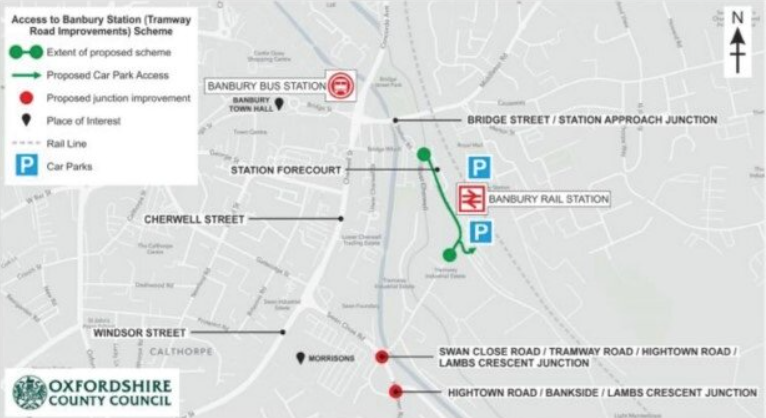
4.27. A significant increase in vehicular use of the Station Approach/Bridge Street junction, north of Canalside, would worsen congestion caused by right-turning movements and threaten the free flow of traffic on the Banbury Inner Relief Road (Cherwell Street) at the Bridge Street junction. The private roads leading from Station Approach also lack the width and alignment to accommodate a significant increase in traffic.
4.28. Planned Tramway Road improvements will support an improved road layout and facilities around the train station, improve bus journey reliability into the town centre from southern areas of the town, and reduce trips taken using the A4260/Bridge Street junction.
4.29. This scheme will also provide an important opportunity to improve access to the station for buses, cyclists and pedestrians, both generally and in particular between the station and the town centre and should reduce traffic and waiting times on Cherwell Street. All development proposals will be assessed against their impact upon the access to Banbury train station (Tramway Road improvements) scheme.
4.30. To eliminate any risk to railway operations and to ensure the safe operation of the railway, applicants must demonstrate that they have met any requirements set out by Network Rail.
Core Policy 65: Development in the Vicinity of Banbury Railway Station
Any proposals for development that may reasonably be considered to have the potential to impact the delivery of improvements to Banbury Railway Station, and in particular, any improvements proposed by Oxfordshire County Council including the Banbury Train Station (Tramway Road Improvements) Scheme (as shown by Banbury Tramway Road Improvements map and the Adopted Policies Map) should demonstrate the proposal would not harm their delivery.
Proposals for improvements to Banbury Railway Station will be supported where they demonstrate how they:
i. Increase network capacity and access to the station and its facilities and to the town centre;
ii. Facilitate and encourage non-car modes of transportation;
iii. Improve the design and quality of the station and its facilities, and
iv. Achieve an increase to the capacity of the station as a result of the
development.
Banbury Tramway Road Improvements
Core Policy 66: Green and Blue Infrastructure in the Banbury Area
4.31. Banbury has a wide range of green spaces including formal sports pitches, play areas, parks and also Spiceball Country Park in the centre of the town. Most of these spaces are maintained and managed by Banbury Town Council.
4.32. The 2015 Local Plan included a long term objective to establish a series of open spaces based on the Oxford Canal and River Cherwell corridors linked by public footpaths/cycleways. This would create a linear park and thoroughfare from the north of the town and Grimsbury reservoir, to a new park at Longford Park south of Bankside.
4.33. The existing Spiceball Country Park forms the central section of the linear park, the new community park at Longford Park provides a focus at the southern end, and the Banbury Country Park provides a major component at the northern end of the town. The whole corridor is included within the North Cherwell Conservation Target Area.
4.34. In reviewing the development proposals for Canalside for this Plan, we now recognise that the canal/river corridor provides an even greater opportunity for an enhanced linear park, which could open up the canal frontage to the town centre, thereby creating a new, attractive public space at a key a gateway to the town.
4.35. The corridor also offers potential for flat, traffic free and pleasant footpath/cycleway routes linking residential areas to employment areas, the town centre, railway station and bus station.
4.36. In terms of sports provision, the town has two indoor leisure centres at Spiceball and Woodgreen, together with some private leisure facilities. Local schools, including the North Oxfordshire Academy, also play an important role in providing sports facilities for the community. Our last Local Plan sought to secure a site for the relocation of Banbury United Football Club, adjacent to Banbury Rugby Club to the south of the town, and we continue to support this objective.
Core Policy 66: Green and Blue Infrastructure in the Banbury Area
The Council will require all development proposals to protect and enhance green and blue infrastructure and assets in the Bicester area as shown by maps in Appendix 6 and the Adopted Policies Map. The Council will seek contributions towards the strategic projects identified in the Cherwell Green and Blue Infrastructure Strategy for the Bicester area including their enhancement and on-going management costs, including:
i. The need for an improved interface between Spiceball Park and the canal/river green corridor linking with the town centre. This should be delivered as part of the town centre enhancements and form a fundamental part of any development proposals;
ii. The continued development of the country park extending the green corridor to the north of the town connecting the urban area with the rural hinterland beyond;
iii. The greening of the town centre, improving east – west connectivity from People’s Park to an enhanced green corridor along the river/canal corridor;
iv. The greening of the primary north – south vehicular route along the South Bar Street/ Horsefair corridor in conjunction with improved traffic solutions to ease congestion in these areas;
v. The development of a new green, accessible link along the southern edge of the development to the south of Salt Way connecting new development and associated open space adjacent to the Bloxham Road in the west and Longford Park in the east, and
vi. The connection of Salt Way to the improved north – south green corridor along the canal/ river corridor.
Planning permission will not be granted for development that would prejudice the construction or effective operation of the schemes listed.
Core Policy 67: Horton Hospital Site
4.37. The Horton General Hospital in Banbury, which is part of the Oxford University Hospitals NHS Trust (OUHT), is an acute general hospital serving the north of Oxfordshire and surrounding areas. It provides a wide range of services, including the Emergency Department. It is a major employer in the town, employing approximately 1,000 people.
4.38. The OUHT has made a commitment to the long-term future of the hospital and is seeking to make significant improvements to its services and facilities over the plan period. Many of the current buildings on the site are low-quality, single-storey buildings and there is scope for increasing the floorspace by redeveloping some of the buildings at an appropriate density and scale.
4.39. The original Victorian hospital building that fronts the Oxford Road is Grade II listed and so any redevelopment proposals would need to retain these buildings and protect them in accordance with the Development Plan as a whole.
4.40. We will encourage and support improved hospital related facilities on the site to serve our existing and future communities.
Core Policy 67: Horton Hospital Site
Proposals for redevelopment at the Horton Hospital will be supported where they provide:
i. Further hospital related uses or improvements to existing medical services at the site; or
ii. Other uses, which have a direct and demonstrable operational link, and provide benefit to the continued provision or improvement of hospital services at the site.
Improvements to public transport access will be required. Mitigation measures will be required to ensure that proposals do not lead to increased parking pressure on nearby residential streets.
The special architectural and historic interest of the original Grade II listed hospital buildings on Oxford Road will be protected in accordance with the wider Development Plan policies.
Primary Health Care
4.41. Evidence from the Oxfordshire Integrated Care Board (ICB) indicates that there is a pressing need for additional primary care space and associated infrastructure within Banbury. The Council will therefore support proposals for additional primary care facilities in the town, in appropriate locations. Such locations could include the town centre or on the Horton Hospital site. The Council will continue to work closely with the ICB and local GP practices to help secure improved primary care capacity across Banbury to meet the needs of its growing population.
Banbury’s Built Heritage
4.42. Banbury has a rich and varied history, which is valued by residents and visitors. The town centre is characterised by its medieval street pattern and across the town there are numerous designated and non-designated heritage assets that contribute to Banbury’s character. Within Banbury there are approximately 225 listed buildings. There are also three designated Conservation Areas. Banbury Conservation Area is centred on the town centre; Grimsbury Conservation Area lies to the east of the railway and canal; and the Oxford Canal is designated along its whole length, including through Banbury. The Council has a legal duty to protect these important heritage assets.
Banbury Town Centre and Areas of Change
4.43. A successful and vibrant town centre is important to the local economy and helps to engender local pride in the town. Independent retailers are well represented in Banbury, particularly in the High Street and along Parson’s Street, and these are complimented by Castle Quay with its range of national retailers.
4.44. Since our last Local Plan there has been significant investment in the town centre with the recent opening of Castle Quay 2 to the east of the existing centre. This major investment by the Council provides a new hotel, cinema, leisure facilities, and restaurants in a canalside location.
4.45. We recognise that in recent years, due to changing retail habits and the impacts of the Covid pandemic, the town centre has suffered. As with many towns, the closure of some large high street chain stores has left several vacant units both in Castle Quay and in the wider town centre. Some smaller units have also closed. This has made some areas of the centre feel less vibrant and attractive to visitors.
4.46. To understand the current strengths and weaknesses and health of the town centre we commissioned a town centre and retail strategy to inform this Local Plan. This Strategy made the following recommendations for Banbury Town Centre:
- Contract the extent of the town centre to create a more compact layout and address the identified oversupply of retail floorspace;
- Resist Out of Centre Expansion as any further expansion will be seriously detrimental to the town centre;
- There should be greater encouragement for residential development in the town centre, to increase the vibrancy of the centre. This will create a stronger in-town community and provide a boost to the local economy from this captive market;
- Support town centre master-planning to ensure a comprehensive strategy;
- Opportunities should be explored to improve the outdoor markets so that they become stand-alone attractions, including by making the market square an attractive destination;
- The centre would benefit from further investment into its public realm and the quality of the environment, to create a more attractive and distinctive space. A Public Realm Strategy would be recommended to raise the profile of the centre;
- Open up the Oxford Canal to the town centre;
- Undertake a review of car parking provisions. Explore partnership options to provide charging points and to meet green agenda targets. Adopt a ‘plain English’ approach to car park messaging. Consider free car parking on market days to stimulate renewed interest in this struggling but important retail offer, and
- Raise the profile of the centre as a night-time economy destination. There should be a focus on managing the existing leisure-offer, and how the nonleisure-based night-time economy could be supported. Improvements to accessibility (particularly late-night transport), the public realm and the sense of safety are recommended.
4.47. The Study also identifies a number of sites suitable for redevelopment, together with areas that need regeneration. Building on the work of the retail consultants we have undertaken further technical and feasibility work and have identified the following sites as being important to meeting the Plan’s objectives:
- Site 1: Banbury Canalside
- Site 2: Bolton Road/Castle Street
- Site 3: Calthorpe Street and Marlborough Road
- Site 4: Bridge Street/Concorde Avenue
- Site 5: George Street, Cherwell Street and Bridge Street
Core Policy 68: Banbury Canalside
4.48. The area of land between Banbury railway station and the town centre, and to the east and west of Tramway Road, is referred to as the Canalside site. It is currently occupied by a range of small businesses, railway carparking, some limited residential development, and Banbury United Football Club. The River Cherwell and Oxford Canal run through the area.
4.49. It is a prominent site immediately adjacent to the town centre and forms part of the gateway to the town for visitors arriving by train and by road. It is, however, currently a relatively unattractive environment that feels segregated and underused. There are vacant areas, high business turnover and industrial uses immediately adjacent to the river and canal towpath, creating a poor environment and experience for those using the canal and river for leisure purposes. Some have reported this area as feeling unsafe.
4.50. Our previous Plan made provision for a comprehensive residential led scheme for the site including 700 new homes, retail, office and leisure uses, public open space, enhancement of the canal and river corridor, new pedestrian and cycle links and crossings and new carparking. Since 2015, planning permission has been granted on a small number of sites within the wider allocated area, mainly for new apartments.
4.51. Many businesses remain and there continues to be a turnover of commercial uses within existing premises. Unfortunately, no significant re-development has taken place and the general character of the area remains largely unchanged, although Oxfordshire County Council is progressing plans for improvements to Tramway Road which will provide a bus-only link through the site to the railway station.
4.52. This Plan continues to identify this area for a mixed-use redevelopment; however, we now expect the development to be employment-led with residential development focused in the northern section of the site and along the Cherwell Street frontage.
Core Policy 68: Banbury Canalside
Development proposals that contribute towards the comprehensive regeneration of the Canalside Area will be supported, including the provision of 500 homes and around 7.5ha employment uses. Proposals for smaller parcels will be supported where the development will positively contribute towards the comprehensive and integrated regeneration of the site as a whole. Favourable consideration will be given to masterplanned and design reviewed proposals that receive a positive appraisal and demonstrate a high level of integration with the town centre and Banbury Railway Station.
Core Policy 69: Banbury Areas of Change
4.53. In addition to Canalside, we have identified other opportunities for development/regeneration. These opportunities could also help to deliver public realm enhancements as part of a wider vision for Banbury town centre. It is important that any proposals are consistent with the new emerging vision/ masterplan for Banbury as part of an aspirational approach to delivering improvements to the public realm, support high quality design and achieve sustainable and successful communities.
Site 2: Bolton Road/Castle Street
4.54. This site lies immediately to the west of the Castle Quay shopping centre and to the north of Parson’s Street. It comprises a large public car park, a number of smaller car parks and service areas associated with the commercial units fronting Parson’s Street, a former car repair workshop, and a number of historic buildings. A former bingo hall is being redeveloped for housing for older people.
4.55. The 2015 Local Plan allocated this site for retail and other town centre uses and residential. Our recent evidence now indicates that town centre uses would not be appropriate in this location and the site is therefore allocated is this plan for a residential led mixed use development.
Site 3: Calthorpe Street & Marlborough Road
4.56. The site is within the designated Banbury Conservation Area and is suited for residential development, with the existing retail operators being relocated within the town centre.
4.57. The Council will support comprehensive and sensitive residential-led redevelopment proposals that incorporate the rebuilding of the frontages to Calthorpe Street and Marlborough Road. Proposals must preserve and enhance the character and appearance of the Banbury Conservation Area. There is a need to provide walking and cycling permeability.
Site 4: Bridge Street/Concorde Avenue
4.58. The site includes the bus station and the eastern end of Castle Quay shopping centre which has a number of vacant units. The site acts as a gateway to the town centre. This site is suited to mixed-use development, including cultural, community, health, and leisure facilities, and residential. Development of this site would require the bus station to be relocated in the town centre.
Site 5: George Street, Cherwell Street & Bridge Street
4.59. The site currently comprises a free-standing bowling alley, adjacent retail unit and car parking accessed from George Street, and retail, commercial and residential buildings fronting Bridge Street. The site is located on a key gateway to the town centre but the built environment, particularly around the Bridge Street/Cherwell Street junction is fragmented and poor. This Plan will support proposals for residential or mixed use proposals on this site which provide a high quality landmark gateway to the town centre.
Banbury Town Centre Areas of Change
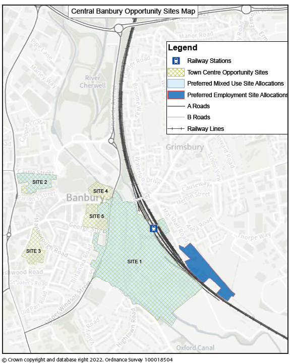
Core Policy 69: Banbury Areas of Change
In addition to Site 1: Canalside, identified in Core Policy 13, there are four additional areas of change identified within or close to the centre of Banbury as listed below and shown on the Policies Map and Banbury Town Centre Areas of Change map:
Site 2: Bolton Road/Castle Street
Site 3: Calthorpe Street/Marlborough Road
Site 4: Bridge Street/Concorde Avenue
Site 5: George Street/Cherwell Street/ Bridge Street
These areas are supported as locations for change and/ or redevelopment in accordance with the following criteria where development should:
i. Be of a high quality, with well-designed edges securing significant townscape improvements to Banbury;
ii. Proposals for the individual sites are prepared through a comprehensive masterplan process providing an integrated solution to site access, traffic management, air quality management, whilst prioritising the pedestrian/
customer environment;
iii. Be sensitive to any surrounding residential areas and the character and setting of the historic core and heritage assets and promote linkages to the historic core of the town centre;
iv. Make a positive contribution to improving sustainable transport connectivity in Banbury, including an increase in capacity and the provision of improved facilities and providing for walking and cycling permeability;
v. Be focused on providing access by sustainable modes of transport including improvements for pedestrians and cyclists such as managed cycle parking facilities, and with no increase in car parking above current levels;
vi. Improve the public realm and by removing unnecessary signage and street furniture, and using a simple and durable palette of materials, and
vii. Residential development will be supported on the identified sites, particularly above ground floors.