Kidlington Vision 2042
6.1 In 2042 the Kidlington area will continue to be an attractive place to live, visit and invest:
- We will have delivered the 4,400 homes already planned to help Oxford’s unmet housing needs
- Kidlington will be a local hub for employment and investment opportunities with attractive services and community facilities
- Our residents and visitors will enjoy a high quality of life with improved access to natural green spaces and affordable housing
- The area will be one of the best connected in Oxfordshire where people can and want to walk, cycle and use public transport
- The economic centres will be vibrant, a place to live, work, shop and access cultural and community facilities
- The quality of the public realm and built environment, will have been improved and new developments will be designed to a high environmental and sustainable standard
- Air quality will have been improved and traffic congestion reduced
- There will be more opportunities for safe, convenient active travel routes
- Public transport will have been improved including inter-connectivity across the four parishes, the rail station and the Langford Lane/Begbroke technology corridor
- There will be more natural and semi-natural open space accessible to the public, including new wooded areas and new linear parks/green corridors.
Kidlington and Parishes Policies
Policy KID 1: Kidlington Area Strategy
6.2 The Kidlington Area Strategy covers the parishes of Kidlington, Gosford and Water Eaton, Yarnton and Begbroke and land within the adjacent Parish of Shipton on Cherwell and Thrupp. To achieve this vision, our strategy for the area is to:
Overall Spatial Strategy
- Strengthen Kidlington’s role as a Local Service Centre
- Improve the built and ‘green’ environment of Kidlington Village Centre
- Continue to support investment in key economic assets including the Village Centre, London-Oxford Airport, Begbroke Science Park and Langford Lane technology corridor
- Ensure the successful implementation of the committed 4,400 homes to help Oxford’s housing needs so that the planned benefits for the communities of Kidlington, Gosford and Water Eaton, Begbroke and Yarnton are delivered.
Kidlington Area Strategy
- Deliver new planned neighbourhoods at Yarnton, Begbroke and Gosford and Water Eaton with community facilities and infrastructure supporting greener sustainable living
- Deliver a modest, heritage and landscape led residential extension to Woodstock of a scale, layout and design commensurate with the character and significance of this historic market town and the significance of Blenheim World Heritage Site and Blenheim Roman Villa
- Support a strong local economy with a focus on high value employment uses at Langford Lane and Begbroke centred on the Oxford Technology Park, London Oxford Airport and Begbroke Science Park
- Secure infrastructure investment for the North Oxford Corridor given its importance as one of the most important transport corridors in the County connecting Cherwell and West Oxfordshire communities with employment and services by public transport along the A44 and Langford Lane
- Secure high-quality well-designed and accessible buildings and public spaces
- Promote an enhanced role for Kidlington as a local service centre with new business and homes in/near the village’s centre and further develop the cultural and leisure/night time economy
- Support proposals that enhance the attractiveness and visibility of Kidlington’s centre
- Improve access for all to high quality community facilities, sports and recreation spaces, and support improved health care facilities with the expansion of existing GP surgeries or a new facility
- Deliver a new secondary school for the wider area
- Bring about Canalside regeneration, including enhancing the gateways to the parishes and improve access to the railway station, and the Technology corridor for the benefit of the wider Kidlington area
- Protect and enhance the character and significance of the natural, historical and cultural environment locally and beyond having regard to local and nationally significant heritage and landscape assets within and bordering Cherwell
- Protect and enhance the townscape and landscape that form the setting of Kidlington, Gosford and Water Eaton, Shipton on Cherwell and Thrupp, Begbroke and Yarnton and maintain their local distinctiveness
- Secure within Cherwell's boundary a permanent, publicly accessible and well-defined high-quality landscape and heritage appropriate edge of town for Woodstock
- Protect and enhance areas of high natural capital value in the Cherwell Valley and the wider region including Oxford Meadows Special Area of Conservation (SAC) and the proposed Otmoor, Bernwood and Ray Nature Park
- Support increased access to nature, open spaces and the Green Belt with specific opportunities to ‘green’ Kidlington’s centre and secure improvements to the Oxford Canal and River Cherwell corridors
- Build on the area’s excellent links to Oxford, Bicester and London by public transport and work with County and Parish councils to deliver safe and inclusive routes that facilitate car free movements as the first choice for residents and visitors
- Support the delivery of Kidlington’s Local Cycling and Walking Plan with new and enhanced walking and cycling routes linking Kidlington to the surrounding villages of Hampton Poyle, Islip, Yarnton, Begbroke, Thrupp, Shipton-on-Cherwell
- Work with the Environment Agency, Thames Water and Oxfordshire County Council to mitigate surface water run off through appropriate sustainable drainage infrastructure and look for opportunities for betterment where flood risk is already present.
Housing
6.3 Over the next ten years some parts of the Kidlington area will see significant change, following the allocation of sites for 4,400 new homes in the 2020 Partial Review of the Cherwell Local Plan. This is planned in six housing allocations located in the north of Oxford (PR6a and PR6b), Kidlington and southeast of Kidlington (PR7a and PR7b) and east and west of the A44 at Yarnton and Begbroke (PR8 and PR9).
6.4 We have prepared development briefs to help the delivery of these new neighbourhoods, guide their integration with the existing local communities and secure new schools and community facilities in the area.
6.5 Any additional proposals to meet Oxford’s unmet needs will be considered against saved Policy PR1: Achieving Sustainable Development for Oxford’s Needs.
6.6 In this Plan we have considered the number and types of homes required to support the needs of the Kidlington area.
6.7 The 2015 Local Plan stated that housing requirements and the development strategy for Kidlington could be achieved “without the need for a strategic review of the Green Belt in the District”, and that “small scale affordable housing schemes to meet specifically identified local housing need may be met through the release of rural exception sites.
6.8 The area’s prosperity, good transport connections and proximity to Oxford are likely to explain higher property prices in this area. The recent increase on the subdivision of larger dwellings may be partly in response to this demand.
6.9 The availability of land outside Kidlington’s urban area is constrained by the Oxford Green Belt. However, Kidlington is one of our most sustainable areas and we have weighed the importance of protecting the Green Belt with wider sustainability factors.
6.10 Policy COM 1 sets out Cherwell's proposed housing distribution. For Kidlington it proposes the delivery of an additional 622 homes to 2042. This approach is taken along with our aim to support efficient use of land within Kidlington's built-up area, avoid further release of green belt and protect green infrastructure.
6.11 We are required to make as much use as possible of suitable brownfield and underutilised land before looking at countryside or Green Belt land. Following examination of housing need and land availability and suitability we consider that a landscape and heritage led allocation at land South-East of Woodstock:
- avoids unnecessary release of the Oxford Green Belt land following its very recent review in 2020
- provides for Cherwell's housing and affordable housing needs in one of the most important transport corridors in the County connecting Cherwell and West Oxfordshire communities
- can deliver development without harm to the outstanding universal qualities of Blenheim Palace WHS and its Grade I Registered Park
- can mitigate any potential impact and address positively the setting of Blenheim WHS and its Park
- can help secure the future of Blenheim Roman Villa Scheduled Monument
- can deliver development without detriment to the setting of the historic market town of Woodstock and Woodstock and Bladon's Conservation areas
- can secure a permanent, publicly accessible and well-defined high-quality landscape and heritage appropriate edge of town for Woodstock
- enables effective cross boundary joint working and cooperation to plan for Cherwell’s identified housing need, support the delivery of local infrastructure priorities in Woodstock and help secure strategic transport improvements in the North Oxfordshire Corridor including a new public transport hub at London Oxford Airport in the vicinity of the Site and future improvements to Hanborough Train Station (within c.2 miles of the site and edge of Woodstock)
- can address positively the cumulative effect of development by delivering strategic housing growth where there is existing and planned infrastructure and support its funding and delivery on site and the locality
- facilitate easier public and active travel access to employment opportunities and facilities in the Langford Lane/Begbroke area and Kidlington village centre.
6.12 The Kidlington Area Strategy will support the delivery of new communities, facilities and accessible open space already committed either side of the A44 and will focus on providing for Cherwell’s needs to 2042 in the southern part of the district including pending aspirations in the adopted Local Plan 2015 and the Kidlington Masterplan SPD to:
- accommodate high value employment (Policy Kidlington 1), creating a new gateway in the Langford Lane/Airport/ Begbroke area
- deliver housing and affordable housing to balance homes and jobs creation in Kidlington and north Kidlington area in particular.
6.13 North Oxford Corridor improvements along the A44, Peartree Interchange and Kidlington are being completed with walking and cycling routes and extended bus lanes to improve access to Oxford City centre, and more reliable public transport and safer active travel for the town and villages along this corridor.
6.14 Many Cherwell and West Oxfordshire residents commute into Oxford and there is also a considerable level of commuting flows between both districts. Recently completed and further planned transport improvements including an A44 transport hub are part of the Central Oxfordshire Travel Plan proposal to reduce car journeys and make the North Oxford Corridor more reliable and safer for all users.
6.15 The historic town of Woodstock is a rural service centre just outside the Oxford Green Belt, bordering Cherwell to the north-west of London Oxford Airport. It is one of the most sustainable settlements in West Oxfordshire and well connected to Begbroke, Yarnton and Oxford and Kidlington via the North Oxford Corridor.
6.16 The edge of Woodstock is approximately 3 km from north Kidlington and major employment growth areas at Langford Lane and Begbroke.
6.17 The World Heritage Site (WHS) of Blenheim Place, with its Grade I Registered Park and Garden, is located to the southwest of Woodstock and is of international and national significance. There is an important physical and historical inter-relationship between Woodstock and the Blenheim estate.
6.18 West Oxfordshire’s adopted Local Plan (2018) acknowledges that despite sensitivities presented by Blenheim Palace WHS there are development opportunities on the edge Woodstock. That Plan allocates Land East of Woodstock (Policy EW3), Land North of Hill Rise (Policy EW4) and Land north of Banbury Road (Policy EW5) at Woodstock to deliver 600 homes to meet West Oxfordshire’s housing needs to 2031 reflecting Woodstock’s historic market town and tourism role and being well served by public transport. Development at Land East of Woodstock immediately north of Cherwell’s boundary is now complete.
6.19 West Oxfordshire’s adopted Local Plan Policy OS2 notes: ‘Woodstock is suitable for a reasonable scale of development, whilst protecting its important historic character and the setting of Blenheim Palace, in order to deliver affordable housing, enhance local services and reinforce its role as a service centre.’
6.20 Woodstock’s Neighbourhood Plan (NP) 2020-2031 was made in 2023. This NP has a specific focus on the designation of Local Green Space in Woodstock. It sets the scene for the strategic sites allocated in the West Oxfordshire Local Plan and provides objectives and policies which guide development.
6.21 Woodstock NP is supported by a Community Infrastructure Delivery Plan, commissioned in 2019 by the Town Council and Blenheim Estate to evidence the infrastructure requirements to deliver site specific infrastructure linked to West Oxfordshire Local Plan sites. The study also presents non-site-specific local infrastructure priorities including a new doctor surgery, a new library, improvements to Marlborough School sports facilities and the relocation of Woodstock Football Club.
The Economy
6.22 Kidlington plays an important role in the wider economy of Cherwell. Its diverse economic base ranges from research and development to light industrial and commercial businesses and it has strong links with Oxford.
6.23 London Oxford Airport (Thames Valley area’s primary regional and business aviation airport), the University of Oxford’s Begbroke Science Park and the wider Langford Lane commercial area sit strategically in the Oxfordshire ‘knowledge spine’ halfway between Oxford and Bicester. Begbroke Science Park is an area identified in the Oxfordshire Local Industrial Strategy for further growth opportunities in advanced engineering and medical technology.
6.24 The 2011 Census travel to work data indicates there were c. 9,700 people living in Kidlington in employment and around 77% of those (8,100 people) were commuting to work. The majority of those commuting to work (44%) travelled to Oxford. As Census 2021 data was collected during the coronavirus pandemic, travel to work data from 2011 remains a more reliable information source.
6.25 We think there is an opportunity to improve the alignment of housing and employment in this area with its good connectivity to Oxford, Bicester and Oxford Parkway. This is likely to support further changes in commuting patterns aligned to sustainable transportation, especially to parts of Oxford and the towns of Woodstock, Bicester and Banbury.
6.26 Our 2015 Local Plan identified the need for a small-scale Green Belt Review around the employment clusters formed by the London Oxford Airport and Langford Lane industrial area, and Begbroke Science Park to support high value employment needs.
6.27 A review undertaken in 2016 concluded Green Belt exceptional circumstances existed and land for area A was removed from the Green Belt in the 2020 Local Plan Partial Review following the Plan’s examination. At the time, it was noted that a new Technology Park had been granted permission in the Langford Lane area (area B) but that it would be for this emerging Plan to address the employment needs.
6.28 Commercial development is already being delivered in the Technology Park at Langford Lane in recognition of the identified need in the 2015 Local Plan and recent planning permissions support commercial development at London Oxford Airport (LOA).
6.29 LOA is a key transport and economic asset of strategic regional significance and plays an important role in supporting Cherwell and Oxfordshire's economy and many of our major employers. We continue to support LOA's economic role and granted permission in March 2024 for further commercial development comprising the redevelopment of existing buildings and provision of approximately 18,700m2 (c. 13,814m2 net) of high value employment uses.
6.30 The airport benefits from permitted development rights for airport related development on its operational land. Policy KID 2 supports the continued use of LOA for commercial aviation and ancillary uses and guides proposals affecting the airport’s operations.
6.31 Policy LEC 1 details how we are planning to meet business and employment needs. In Kidlington, this entails the delivery of the Oxford Technology Park at Langford Lane (currently under construction) and 14.7 hectares of land for the expansion of Begbroke Science Park on the land in saved Policy PR8 for which there was a resolution to grant outline planning permission in September 2024, as well as delivery of high value employment uses at LOA, also recently permitted.
6.32 Begbroke Science Park hosts the Oxford University departments of Engineering Science and Materials, the Oxford Materials Characterisation Service and a large number of successful spin-outs and start-ups leading on research and technology. The expansion will support Oxford University in transforming the science park into an Innovation District and deliver the Oxfordshire Local Industrial Strategy’s aspirations for the development of a major innovation quarter for UK and international collaboration and commercial research and development.
6.33 Saved Policy PR8 together with the recently permitted extension of Begbroke Science Park will establish a highly sustainable and innovative urban neighbourhood with strong links to Kidlington Village Centre, to Oxford, and nearby communities of Yarnton and Begbroke and beyond.
6.34 The airport is a regional centre for commercial aviation and training. There may be opportunities for further research and technology business to be established at or near the airport, but we would like to ensure the airport has sufficient land for operational purposes now and in the future without placing undue pressure on the larger site area where the potential harm to Green Belt purposes may be greater.
6.35 There is a clear opportunity to support an innovation district centred around Begbroke/Langford Lane/Oxford Airport. The Kidlington area will see significant change with committed and planned housing and infrastructure investment alongside recent commercial commitments and Policy LEC 1. The role of this Plan and the Council will be to support, guide and secure the delivery of those commitments with public sector partners, employers, investors and the local community.
Kidlington Area Heritage
6.36 The heritage and history of Kidlington and surrounding villages is closely related to the setting of the River Cherwell, their proximity to Oxford and the 19th century developments of the Oxford Canal and railway. Kidlington and the Parishes of Gosford and Water Eaton, Yarnton, Begbroke and Shipton on Cherwell and Thrupp fall within the Lower Cherwell Flood Plain Landscape Character Area. It is important that we retain the role of the area’s rivers, smaller watercourses and the Oxford Canal as distinctive landscape features contributing to a sense of place in the strategy area and preserve a separation between settlements, to avoid perceived coalescence of Oxford, Kidlington, Yarnton and Begbroke.
6.37 The villages are predominantly inset within the Oxford Green Belt, which amongst other purposes, intends restraining development pressure which could affect the character of Oxford City and its heritage setting.
6.38 The Oxford Canal is a designated Conservation Area along its whole length, including through Kidlington. Many of the Canal bridges and locks are listed. Langford Lane Wharf Conservation Area remains in use and retains part of its late 18th century early 20th century commercial character.
6.39 The 13th Century Grade I Listed Church of St Mary the Virgin is the focal point of the Church Street character area, prominent in views from across the flood meadows of the River Cherwell and forms an important view to the wider setting of Hampton Poyle Conservation Area north of the River Cherwell.
6.40 Crown Road Conservation Area, west of the Oxford Road is the site of a former Manor which retains historic and architecturally important 18th and 19th century housing. Begbroke’s Conservation Area, west of the A44 includes nine buildings and their grounds. The special character of the Conservation Area is the use of local materials in traditional styles within large maturely vegetated plots, bordered by dry stone walls. Care should be taken to ensure that the open parts of the Conservation Area and the land which make up its setting and impact positively on its appearance remain open.
6.41 In the wider setting, the World Heritage Site (WHS) of Blenheim Palace, registered park and associated setting on the southeast edge of Woodstock are of high significance. The setting of the Scheduled Ancient Monument, the ancient route of the ‘Ridgeway’ along the West Oxfordshire/Cherwell border and the proximity of Bladon Conservation Area are also important heritage considerations.
6.42. The grounds of Blenheim Palace World Heritage Site (WHS) are situated to the east of the A44 in close proximity to London Oxford Airport that sits in the Oxford Green Belt. To the north of the airport and adjoining Woodstock’s boundary there are the buried remains of a Roman villa and associated fields, the designated Blenheim Villa Scheduled Monument.
6.43. North of Campsfield Road, existing woodland belts contain views of the approach to Woodstock and other wooded areas such as Campsfield Wood, in contrast with the openness of the landscape to the south.
Policy KID 1: Kidlington Area Strategy
Our over-arching priority for this area is to secure the aligned delivery of housing and employment together with the infrastructure required to achieve sustainable development.
Development in the Kidlington Area should be in accordance with the Settlement Hierarchy set out in Policy SP 1.
Housing Delivery: 5,022 homes will be delivered in the Kidlington area between 2020 and 2042 including the following strategic site allocations:
| Site | Housing numbers 2020-2042 | |
| South-East of Woodstock | 450 | New Site Allocation |
The following existing strategic site policies are retained and will not be replaced:
- Policy PR6a – Land East of Oxford Road
- Policy PR6b – Land West of Oxford Road
- Policy PR6c – Land at Frieze Farm
- Policy PR7a – Land South East of Kidlington
- Policy PR7b – Land at Stratfield Farm 1
- Policy PR8 – Land East of the A44
- Policy PR9 – Land West of Yarnton.
A further allowance will be made for ‘windfalls’ of less than 10 dwellings on previously developed sites within the built-up area of Kidlington
Employment: 14.7 hectares of employment land will be provided for business and employment growth within Policy PR8 – Land East of the A44 for the expansion of Begbroke Science Park.
Policy KID 2: London-Oxford Airport
6.44 The London Oxford Airport (LOA) operates as a private airport and is the area’s primary regional and business aviation centre. LOA is the only commercial airport between Birmingham and London Heathrow and makes a significant contribution to the local and regional economy as a major infrastructure facility, local employer and supports the growing knowledge base and innovation sector in the area.
6.45 Current airport activities include general, and business aviation uses, pilot training base (CAE Oxford Aviation Academy) and aircraft maintenance. Airbus Helicopters UK’s headquarters are based at the airport. Complementary activities include aerospace/aviation related industries and research and development.
6.46 Construction of a new c. 7,000m2hangar with two bays including rear offices, stores and workshops commenced in 2021.
6.47 LOA intends to set a programme for the replacement of existing older hangars with new facilities. It will be important that the airport’s future and modernisation plans embrace all opportunities for carbon reduction, from the use of Sustainable Aviation Fuel (lifecycle carbon reduction of up to 80% compared to the traditional jet fuel) to more efficient aircraft design, and the development of future technologies like electrification.
6.48 LOA benefits from permitted development rights which in consultation with the Council could allow airport related development on the airport’s operational land.
6.49 Support will be given to appropriate aviation related development proposals and the airport’s contribution to the local and regional economy. The Council will seek clear mitigation measures effectively addressing any aviation related environmental or health concerns.
6.50 Airport safeguarded areas refer to a designated zone of exclusion, in which the Aerodrome Operator can, in consultation with the Local Planning Authority, consult on development proposals to protect the environment surrounding the airport from development. Reasons for preventing development would include activities that have the potential to impact the aerodrome’s safe operation, or sensitive development that would likely be negatively and inappropriately impacted by the aerospace itself. Safeguarding ensures:
i. Buildings and structures in the area do not pose a danger to aircraft;
ii. The integrity of radar and other electronic aids to navigation are not affected;
iii. Inappropriate lighting is not present, to avoid confusion with aeronautical lighting;
iv. No increase in wildlife risk (e.g. bird strikes);
v. Operations that could create interference through construction processes are prevented, and
vi. Aircraft are not impacted by potential ‘glint and glare’ from development (e.g. solar panels).
6.51 LOA’s safeguarded airspace measures two nautical miles (3.704km) in radius, centred around the Airfield Reference Point, the mid-point of the main instrument runway.
6.52 Airport related development within the safeguard area, and elsewhere, must be held to the same standards as other development, as set out within the supporting policies.
Aircraft noise
6.53 Aircraft noise is generally exempt from the general noise nuisance controls. The Department for Transport (DfT) is responsible for the control of aircraft noise. However, the Civil Aviation Authority indicates the overall policy is that noise issues are best handled at a local level by the airport and the relevant local authority, engaging with people who are affected by noise.
6.54 In order to determine whether or not any specific development is likely to increase ‘noise nuisance’ from aircraft, the Council will seek to assess the impact of that development in terms of:
i. The number, location, duration and frequency of aircraft activities or movements;
ii. The noise levels and sound frequencies (Hz) associated with individual aircraft activities or movements;
iii. The noise levels and sound frequencies (Hz) associated with overall aircraft activities or movements;
iv. Seasonality of aircraft activities or movements, and
v. The time of day at which aircraft activities or movements take place.
Policy KID 2: London Oxford Airport
The Council will support the continued use of London Oxford Airport for commercial aviation and ancillary uses.
The Council will consult with the airport operator on proposals in the airport’s safeguarded areas, as shown in Appendix 9. Development that may be a hazard to aircraft safety will not be permitted.
In consultation with the Airport Operator, the Council will ensure that:
i. Areas included in airport safeguarding areas are protected from development, and
ii. Sensitive uses such as housing, education and hospitals are not located in areas significantly affected by aircraft noise without acceptable mitigation measures.
Development proposals at the airport should include mitigation measures to address any environmental and health impacts, particularly in respect of noise, air quality, health, and climate change in compliance with other Development Plan policies.
Any proposals for development on the wider airport, that fall within the Oxford Green Belt, will need to comply with related Development Plan policies, including for development in the Green Belt.
Policy KID 3: Delivery of Transport Schemes within the Kidlington Area
6.55 The North Oxford Corridors are very well connected with the Oxford Road/Banbury Road (A4260) and Woodstock Road (A44) linking Kidlington and surrounding villages with Oxford City centre, Woodstock and the north of Cherwell. The A34, A40 and Oxford Parkway railway station provides easy access to Bicester, Oxford, London and the wider region. Hanborough Rail Station c.2 miles from the A44 provides services to Oxford, London and Worcester.
6.56 Langford Lane and Upper Campsfield Road (A4095) to the north, and Frieze Way (A4260) to the south are important east-west connecting routes between the A44 and A4260 corridors.
6.57 The A34 is a major strategic route carrying freight from Southampton to the Midlands. It crosses the western edge of Kidlington and Gosford as it runs from Bicester Junction 9 of the M40 to Peartree interchange north of Oxford.
6.58 The local road network suffers from congestion on its main routes, particularly on the accesses to Oxford.
6.59 However, Cherwell’s 2020 Local Plan Partial Review and the recently adopted Central Oxfordshire Travel Plan (November 2022) set out a clear strategy and infrastructure programme for investing in public transport and active travel in the Kidlington area. Given its proximity to Oxford the Local Plan will make the most of the locational advantage and good public transport links in the area to ensure development meets the ambitious shift to car-free travel in the Oxfordshire Local Transport and Connectivity Plan.
6.60 Oxfordshire County Council and other transport partners have delivered bus routes providing easy and frequent access to Oxford and Bicester and main employment areas, the opening of the Oxford Parkway railway station in 2015 a southbound bus lane and shared walking/cycling facilities on the A44 between Cassington Road roundabout and through the Pear Tree Interchange;
- the full signalisation of Pear Tree Interchange
- sustainable transport improvements through North Oxford
- bus and cycle improvements at Kidlington roundabout.
6.61 We know there is already a high level of cycling commuting in Kidlington and the walking and cycling proposals in the adopted Kidlington LCWIP will extend safer active travel opportunities within the village and to neighbouring rural areas by linking Kidlington to the villages of Hampton Poyle, Islip, Yarnton, Begbroke, Thrupp and Shipton-on- Cherwell. A Woodstock LCWIP is under preparation and will consider routes and improvements between the town and the wider area including Begbroke.
6.62 It is important that transport schemes do not simply focus on improving road corridors for their highway function but that good design supports place shaping and movement within communities. We will support the delivery of 20-minute neighbourhood concept through our design and active travel policies COM14 and COM 15.
6.63 Most transport corridors feel removed from communities and services, this is not our case. Our main arterial routes serve directly existing and planned communities at Begbroke, Yarnton and Kidlington and neighbouring communities beyond.
6.64 Policy KID 3 seeks to secure the infrastructure needed to promote healthy alternatives to travel and improve the efficiency of the local road network.
6.65 Policy KID 4 focuses on aligning transport and green infrastructure including east-west active travel improvements across the Oxford Canal and the greening of Kidlington’s centre.
6.66 We will work with Oxfordshire County Council to ensure that they are designed and delivered to serve community needs, contribute positively to a sense of place and support both social and economic wellbeing in consultation with the local community. The following local area strategies focusing on place shaping and delivery are currently under preparation:
- A44/Woodstock Road Area Travel Plan
- Kidlington Area Travel Plan
- Kidlington Infrastructure Strategy.
6.67 The Water Eaton and Peartree Park and Ride sites on the boundary with Oxford provide approximately 1,800 car parking spaces between them. Their main function is the removal of private vehicles from the main corridors into Oxford to help reduce congestion.
6.68 In the 2020 Local Plan we indicated the location of a potential Park and Ride on the A44 within London Oxford Airport land to help reduce congestion on the A44 and the A4260 into Oxford and Kidlington.
Safeguarding of Land for A44 Mobility Hub
6.69 Following the publication of the Oxfordshire Mobility Hub Strategy (July 2023), the proposed A44 Park and Ride indicated in the 2020 Cherwell Local Plan Partial Review is now known as a Mobility Hub and has been categorised as a Major Interchange Hub to include:
a) A variety of bus services, including rapid transit routes;
b) Digital pillar/app/QR code with transport info, ticketing, way finding, walking and cycling distances to local services;
c) High quality pedestrian and cycle routes to and from the surrounding area;
d) Combination of cycle parking and secure cycle storage (for all bicycle types);
e) Car parking prioritised for disabled users;
f) Bike tyre pumps and repair stations;
g) Toilets, showers, changing areas;
But could also include:
h) Car club bay (s) with appropriate types of vehicles;
i) Improved public realm: green spaces/community art/pavement repairs/safer road crossings;
j) Taxi services, and
k) Hydrogen fuelling capabilities.
6.70 The proposed A44 Mobility Hub site is located along the A44 adjacent to Woodstock/A44 roundabout on the edge of the London Oxford Airport site.
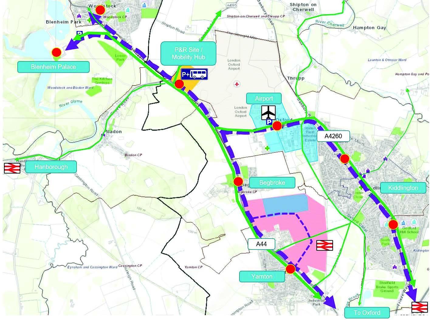
Figure 8: A44 mobility hub diagram
6.71 The site is in the Oxford Green Belt on land owned by London Oxford Airport (LOA). Blenheim Palace World Heritage Site (WHS) and Grade I Listed Park and Garden are located to the west and north of the A44/A4095 roundabout.
6.72 Transport infrastructure which can demonstrate a requirement for Green Belt location is not inappropriate development in the Green Belt provided it preserves openness and does not conflict with the Green Belt purpose. Proposals for the A44 Mobility Hub will be assessed against Local Plan policies including Policy COM 26 Historic Environment and Policy COM 12 The Oxford Green Belt.
6.73 Land for the A44 Mobility Hub is safeguarded as shown in the Policies Map. The evidence paper, ‘A44 Mobility Hub: Justification for the Safeguarding of Land in the Cherwell Local Plan Review 2042’ sets out the context and background for the proposal including the consideration of alternatives and justifies land safeguarding to secure its delivery.
Policy KID 3: Delivery of Transport Schemes within the Kidlington Area
We will work with Oxfordshire County Council to secure community environments that make active travel convenient, safe and attractive. Transport infrastructure has been identified to mitigate the impact of planned growth and improve the efficiency of the road system to help secure a viable and sustainable future for Kidlington, surrounding villages and beyond. The package of measures may be further refined through development of strategies being developed by Oxfordshire County Council as part of the Local Transport and Connectivity Plan suite of documents.
Transport infrastructure in the Kidlington area will be required as follows:
i. Improved bus services and facilities along:
a. The A44/A4144 corridor linking Woodstock and Oxford;
b. The A4260/A4165 (Oxford Road) linking Kidlington, Gosford, Water Eaton and Oxford;
c. Langford Lane, and
d. a new Mobility Hub on the A44 as shown in the Policies Map;
ii. Segregated cycleways where possible and shared paths where there is a lack of room or usage levels are expected to be lower along the A44, including sufficient pedestrian and cycle crossings to improve placemaking along these corridors;
iii. The prioritisation of the A44 over the A4260 as the primary north-south through route for private motor vehicles into and out of Oxford;
iv. Improved rapid transit/bus services and associated Super Cycleway along the A4260 into Oxford;
v. Improvements to the public realm through the centre of Kidlington;
vi. The provision of new and enhanced walking, cycling and wheeling routes into and out of Oxford, and
vii. The provision of the proposed active travel network in Kidlington’s Local Cycling and Walking Infrastructure Plan (LCWIP).
All development within the Kidlington area will be required to contribute in accordance with Policy COM 20: Providing Supporting Infrastructure and Services. This will include contributions towards the infrastructure identified within the Infrastructure Delivery Plan (IDP).
Community facilities and infrastructure
6.74 Our communities have a good range of community facilities. Recreational spaces and sports grounds, including Orchard and Park Hill recreation grounds, Rutten Lane, Ron Groves, Exeter Close and Stratfield Brake, provide green space, sports and play facilities serving the wider area alongside smaller green spaces and play parks.
6.75 Six primary schools at Kidlington, Gosford and Yarnton, a secondary school at Gosford Hill and further planned primary and secondary schools at Begbroke and Water Eaton will serve current and future education needs.
6.76 The Integrated Care Board, local GP practices and parish and district councils have explored opportunities for new health care facilities to extend the patient capacity of the two GP practices. Exeter Hall has been the preferred location for a health hub for some time but with the local GP practices already at capacity, other opportunities including increasing capacity at Yarnton may need to be secured if feasibility work undertaken by the Parish Council shows Exeter Hall cannot accommodate a health centre expansion.
6.77 Evidence supporting the 2015 Local Plan and the 2016 Kidlington Master Plan indicated a shortage of parks and gardens, allotments and playing pitches in the area.
6.78 Our 2020 Local Plan addressed this shortage with new natural and seminatural open spaces, recreational areas and formal sports provision including c. 4 hectares of land for strategic sports provision south-east of Kidlington complementing key sports facilities at neighbouring Stratfield Brake.
6.79 We will deliver this commitment and set up new policies in the emerging Plan seeking the protection of existing and planned facilities and setting standards for new provision through new development.
6.80 The leisure centre at Gosford and health and fitness offer at Langford Lane provide for indoor sports facilities but further facilities will be required to 2042. The planned secondary school at Begbroke is expected to offer shared use of a new four-court sports hall and the swimming facilities at Kidlington and Gosford Leisure Centre will require expansion.
6.81 The 2020 Local Plan Partial Review addressed some of the green Infrastructure and recreational open space opportunities along the canal identified in the 2016 Master Plan and provides for additional facilities in the area including two new primary schools, an extension to William Fletcher Primary School and a new secondary school.
6.82 There is now some certainty on the proposed developments at Begbroke and Yarnton further to saved Polices PR8 and PR9 means that we can start working on the delivery of these and other important community facilities.
6.83 The catchment for Woodstock CE Primary School includes Begbroke and that of Marlborough CE Secondary School also in Woodstock extends to Begbroke and Yarnton. Committed new school provision in the Yarnton and Begbroke area will improve access to education in the Kidlington area and Woodstock.
6.84 The Infrastructure Delivery Plan (IDP) that accompanies this Plan assessed the need for open space, community facilities and infrastructure needed to support the Kidlington Area Strategy including those to secure a sustainable heritage led extension to Woodstock (Policy KID H1). The provision and requirements in the IDP will be secured in accordance with Policy COM 19.
6.85 The River Cherwell and Oxford Canal are important green infrastructure corridors for biodiversity and active travel connecting Kidlington towards Oxford and gives access to the wider countryside beyond. Open spaces and areas of high natural and landscape value stretch along the river and canal lengths and frame the setting of Kidlington, surrounding villages and that of Oxford. The area includes open spaces such as the woodland and wetland habitats at Stratfield Brake, Begbroke Wood Local Wildlife Site and Rushy Meadows Site of Special Scientific Interest as well as the open spaces in the Lower Cherwell Conservation Target Area. All of which contribute to Oxfordshire’s nature recovery network.
6.86 The Cherwell Green and Blue Infrastructure Strategy 2022 has been prepared to ensure we, our partners and local community, have a framework which supports increased access to nature, open space and the Green Belt, help us conserve our heritage, landscape and natural environment, makes us more resilient to climate change and support active travel.
6.87 This place strategy addresses the network of green spaces and routes, landscape and water features shaped by the canal and River Cherwell as well as the greening of Kidlington’s urban area. The strategy identifies area specific opportunities and sets projects for the protection of green spaces and increased wider benefits to people and biodiversity. Importantly, it sets the area in a wider natural context with links to important spaces within the Oxford Meadows and Farmoor conservation target area and the Oxford Meadows Special Area of Conservation further south.
6.88 Priorities to 2042 include:
- Protecting the function of the river Cherwell floodplain;
- Protecting areas of green space of high natural capital and nature recovery value in the Lower Cherwell Valley, Oxford Meadows and Farmoor and Blenheim and Ditchley Parks Conservation Target Areas (CTAs);
- Improving blue corridor connectivity along the canal and river corridors;
- Supporting active travel through integrated green infrastructure to help reduce daily commutes to Oxford;
- Supporting improvements to the River Cherwell’s water quality.
6.89 Further priorities may be identified following consultation on the emerging Oxfordshire Local Nature Recovery Strategy.
Policy KID 4: Kidlington Area Strategy - Green and Blue Infrastructure
All development proposals will be required to protect and enhance green and blue infrastructure in the Kidlington Strategy Area.
The Council will seek contributions towards the strategic projects identified in the Cherwell Green and Blue Infrastructure Strategy including their enhancement and on-going management costs, including:
i. Expanding and enhancing the network of footpaths and trails;
ii. Enhancing the Oxford Canal and River Cherwell blue corridors;
iii. New and enhanced access to the canal and river, and
iv. Greening Kidlington village centre and supporting walking and cycling.
Planning permission will not be granted for development that would prejudice the construction or effective operation of the schemes listed.
Policy KID 5: Development within and Adjoining Kidlington Village Centre
6.90 In the past ten years, recent retail/town centre developments, with office and residential uses above and public realm improvements, have helped consolidate the village centre. Today, the centre has a strong service offer and very low vacancy rates.
6.91 Looking to 2042, investing in village centre spaces and improving their accessibility and visibility will be key to support Kidlington’s role as a local service centre.
6.92 The recent completion of a 100-room hotel at Langford Lane has helped increase the accommodation offer in the area. Enhancements to the Oxford Canal and River Cherwell corridors and a focus on strengthening the village centre and public realm will increase opportunities for leisure activities and improve the attractiveness of the area as a destination.
6.93 Our Retail and Town Centre Study made specific recommendations for the village centre and its spaces including:
i. Prioritise improvements to the public realm and arrival experience to the centre:
- Improve the attractiveness of the Banbury Road/Oxford Road approach to the village centre to enhance arrival experience;
- Provide a gateway to the village centre;
- Increase the visibility Kidlington Centre as a whole and Kidlington Centre arcade including further signage, and
- Improvements to make the west of High Street/Watts Way area a focal point and increase its use.
ii. Encourage clustering of evening economy/leisure uses for example around the pedestrianised square (west of High Street/Watts Way);
iii. Improve the availability of private and affordable housing and senior living in the village centre;
iv. The village centre boundary should broadly reflect the existing boundary except for a residential dwelling to the west of the Black Bull Public House which is recommended to be removed, and
v. Drawing a compact Primary Shopping Area.
6.94 Our evidence indicates we should be directing retail development to the Primary Shopping Area only and leisure uses to the village centre as a whole. This is to avoid overprovision of retail floorspace and support stronger relationships and connections between retail uses.
6.95 The village centre boundary and a primary shopping area is shown on the Policies Map.
6.96 Saved Policy PR6a will enable the provision of a small-scale neighbourhood centre at Gosford and Water Eaton in proximity to the Oxford Parkway.
6.97 The development proposed within saved Policy PR8 will support further facilities and complimentary uses commensurate with the emerging innovation centre at Begbroke centred on Begbroke Science Park. Work on the emerging Kidlington and A44/Woodstock Road Local Travel Plans and the Kidlington Infrastructure Strategy will take forward policies and proposals in this Plan and help us deliver place base initiatives in consultation with the local community.
6.98 The Town Centre and Retail Study identifies two sites with regeneration opportunities within and close to Kidlington village centre:
Site 1: Skoda Garage, Oxford Road/Lyne Road
Site 2: Watts Way Piazza.
6.99 Further technical and feasibility work will need to be carried out to understand the potential of these opportunity areas, but the sites are considered important to improve the visibility and attractiveness of the village centre and secure public realm enhancements. They also provide the opportunity to encourage smaller independent businesses into the village centre. Any future proposals should not preclude the delivery of these village centre improvement opportunities.
6.100 The 2016 Kidlington Framework Master Plan identified a number of other sites with regeneration potential, the Co-op car park has now been completed but Exeter Close has property constraints which affect the consideration of development proposals.
6.101 Exeter Close is an important civic space in the vicinity of the village centre with uses including a community hall, medical practice, recreational open space and sports provision. We are committed to continue working with partners to deliver this site if an appropriate development proposal comes forward. Proposals should respond positively to the features and special interest of Crown Road Conservation Area and its setting immediately to the west of Exeter Close.
6.102 We are proposing a criteria-based policy to guide the development of these sites and any other opportunity area arising through the Plan period. We are committed to continue working with partners to deliver Exeter Hall if an appropriate development proposal comes forward.
Policy KID 5: Development within and Adjoining Kidlington Village Centre
Development within or close to the centre of Kidlington will be supported as locations for change and/ or redevelopment in accordance with the following criteria where development should:
i. Be of a high quality, with well-designed edges securing significant townscape improvements to Kidlington;
ii. Proposals for the individual sites are prepared through a comprehensive masterplan process providing an integrated solution to site access, traffic management, air quality management, whilst prioritising the pedestrian/ customer environment;
iii. Be sensitive to any surrounding residential areas and the character and setting of the historic core, conservation areas and heritage assets and promote linkages to the village centre;
iv. Have regard and respond sensitively to amenity matters including noise, daylight/sun light and privacy to prevent adverse impact on the amenity and use of North Kidlington Primary School and its playing areas;
v. Make a positive contribution to improving sustainable transport connectivity in Kidlington, including an increase in capacity and the provision of improved facilities;
vi. Be focused on providing access by sustainable modes of transport including improvements for pedestrians and cyclists such as managed cycle parking facilities, and with no increase in car parking above current levels, and
vii. Improve the public realm and by removing unnecessary signage and street furniture, and using a simple and durable palette of materials.
Residential development will be supported within proposals, particularly above ground floors.
Policy KID H1: South-East of Woodstock
6.103 South East of Woodstock is a green field site located north of Kidlington in the Shipton on Cherwell and Thrupp Parish and immediately adjoining the historic town of Woodstock (1.3km of the town’s historic urban core). Located in the A44 corridor, the site has been previously proposed for development but deemed by the Local Plan Inspector too distanced from Oxford to deliver Cherwell’s apportionment of Oxford’s unmet needs.
6.104 The site comprises a c. 48.7ha arable field, modern in character and cultivation, bounded:
- northwest by a 20th century housing development, one of a series of urban extensions to the historic town of Woodstock, and recently completed housing development at Park View.
- southwest by a small wooded site, Campsfield Wood, and the walled and treed edge of the enclosed parkland of Blenheim Palace. The site is separated from these by the A44.
- southeast by the A4095 (Upper Campsfield Road) and on the other side of that stands London Oxford Airport.
- northeast by Shipton Road, on the other side of which is a 19th century house surrounded by rectilinear fields, also in arable use.
6.105 The site comprises a large, open agricultural field with limited identified semi-natural habitats or valued natural features. It is bounded to the south and west by hedgerows containing some mature trees. The eastern and northern boundaries are defined by linear tree belts which are identified as Priority Habitat ‘deciduous woodland’.
6.106 The lakes and High Park at Blenheim Palace some 1.3 km west and northwest of the site are a designated Site of Special Scientific Interest (SSSI). Shipton- on-Cherwell and Whitehill Farm Quarries geological SSSI lies c. 1 km to the northeast and Rushy Meadows SSSI some 2 km to the south. Development proposals will be required to comply with Policy CSD11 on protection and enhancement of biodiversity and demonstrate that designated environmental assets will not be harmed.
6.107 It is located close to the north-eastern boundary of the Blenheim Palace World Heritage Site (WHS)and Registered Park and Garden (RPG), separated from it by the A44. Blenheim Palace is a historically significant area for both its palace and landscape. The 2017 WHS Management Plan was prepared under the guidance of Blenheim Palace, Historic England, Natural England, DCMS, ICOMOS-UK, Oxfordshire County Council and West Oxfordshire District Council. The Management Plan illustrates the areas of potential intervisibility, areas vulnerable to permanent development and woodlands and plantations contributing to the setting of the WHS.
6.108 Mature tree belts enclose the majority of the northern and eastern boundaries of the proposed allocation site, limiting views into and out of the site. The southern boundary is defined by relatively low hedgerow and a few hedgerow trees and is thus more open. The opposite side of the A44 features a dense woodland of mature deciduous trees which form an effective screen to views from the WHS and RPG at Blenheim Palace and Shakespeare Way long distance path.
6.109 The western edge of the site borders recent residential development on the edge of Woodstock. A Landscape Sensitivity Assessment of the site informs this proposed allocation and policy requirements.
6.110 The proposed allocation is in an area of high archaeological sensitivity. It contains a scheduled monument and associated nationally significant Roman remains, and is located in an area with a well preserved record of Roman activity. Iron age remains of regional significance have also been found within the Site and the vicinity. There is also some potential to encounter locally important palaeolithic to bronze age, medieval and post medieval archaeological remains.
6.111 The Site has been extensively investigated providing a high level of certainty as to the extent and significance of these remains, and the chance of encountering unknown remains is likely to be low. The whole extent of the site and beyond was investigated in 2014 by Thames Valley Environmental Records including the excavation of 265 trenches. Two major areas of occupation were identified. One to the north of the Blenheim villa scheduled monument (HER ref: 28570) and one located at the north-east of the Site (HER ref: 28571).
6.112 There is a Scheduled Monument inside the site (west area), protecting the buried remains of Blenheim Roman villa. The villa was recently removed from the national Heritage Risk Register following agreement with the landowner not to plough the site in the period 2021 - 2025. Although underground, the villa remains are considered of high evidential value to substantiate the use and development of the villa and its relationship to the surrounding area. The villa is likely to have had an east, south-east orientation or outlook which is significant to the villa’s setting.
6.113 The site has limited physical and visual relationship with Conservation Areas, Bladon c. 800m to the south and Woodstock c. 950m to the west.
6.114 A Heritage Impact Assessment (HIA) was prepared in consultation with Historic England and informs the site allocation and policy requirements. The HIA includes assessments of significance, sensitivity and risk of harm and level of effect/potential harm including cumulative effect. The study considered designated and non-designated heritage assets within the site and within 500m - 2km of the site.
6.115 In addition to assessing Blenheim Palace, its Registered Park and Garden and other heritage assets in the area, the HIA focused also on Blenheim Palace as a World Heritage Site (WHS), its outstanding universal value and the reasons for its inscription in the WHS list.
6.116 The site has previous Local Plan examination and planning applications history, and we engaged extensively including with Historic England and West Oxfordshire District Council as part of those processes and the preparation of this Local Plan including through the preparation of Statements of Common Ground.
6.117 Previous conclusions from Local Plan Inspector recommended the removal of this site in the context of meeting Oxford’s unmet needs and the availability of sites proposed closer to Oxford which could through re-design accommodate an increased number of homes. Additional reference to setting and layout of the proposal did not fully recognise the influence of Blenheim Villa on site and the landscape and heritage led approach to the policy requirements and sitting of development as the reason for removal lay primarily with the separation from Oxford.
6.118 Historic England recommended the preparation of a proportionate Heritage Impact Assessment and encouraged the Council to draw from the heritage and mitigation evidence prepared in support of the Cherwell Local Part 1 Partial Review in relation to Land South-East of Woodstock.
6.119 We have drawn from current and recent Historic England advice on Local Plan preparation and planning applications. Advice indicates that:
On Blenheim WHS and setting of Woodstock
- there is no intervisibility between the proposed site and the WHS, only tree-screened glimpsed views across the A44 on the northwestern corner of the site
- the site to makes a very minor contribution to the communal value of the WHS which could potentially be mitigated with good design
- the experience of those approaching along the A44 from the Oxford direction view the WHS set in the countryside on the edge of the market town of Woodstock
- the proposed allocation site is experienced as an agricultural field glimpsed through a hedge in the approach to Woodstock
- Shipton Road, bordering the north of the proposed site is not considered to be part of the WHS setting.
On Blenheim Roman Villa
- The villa remains have high evidential value as shown by geophysical survey and evaluation trenching. The setting of the villa makes a modest contribution to the significance of the site, illustrating its original outlook and surroundings. It also illustrates the agricultural estate of the original villa on which its economy would have depended, at least in part
- Aesthetic value is negligible and communal value is currently limited mainly to the interest of specialist groups
- Need detailed policy to clarify that residential development on the SM or in a location which may harm its significance through the impact of its setting would be inappropriate.
In preparing the Local Plan Review 2042 we have reassessed the landscape impact of this site and in compliance with Policy COM 10 development proposals are required to provide a landscape and visual impact assessment.
6.120 These documents and their recommendations inform Policy KID H1 to ensure that development proposals address the WHS outstanding universal value and do not harm the WHS and its setting. They also help ensure the layout of the proposal and management plan secure the future of the Schedule Monument on site.
6.121 Landscape, heritage and infrastructure specific evidence inform the site’s suitability for allocation and the drafting of policy KID H1 requirements.
6.122 We have had regard to relevant environmental and heritage policies and objectives in West Oxfordshire’s Local Plan to ensure the requirements in Policy KID H1support the continued role of Woodstock’s as a historic market town and major tourism destination.
Policy KID H1: South-East of Woodstock
Site area: 48.7 hectares
Developable area: 16 hectares
Land south-east of Woodstock is allocated to accommodate 450 dwellings as a landscape and heritage led extension of the existing built form of Woodstock as shown on the Policies Map.
Planning permission will only be granted for development in accordance with a comprehensive masterplan and design code submitted to, and approved by the Council.
A sensitively laid out and designed development of limited scale set back from the southern boundary of the site and the A44/Oxford Road. A positive gateway to Woodstock and Blenheim World Heritage Site and Grade I Park providing a publicly accessible and high-quality edge of town.
All development proposals will be required to meet the following site specific requirements in addition to those set out in the relevant district-wide policies in this Plan.
Proposals must follow a landscape and heritage led approach to design which secures the long-term future of Blenheim Roman Villa on site and a landscape and planting strategy which is commensurate to the WHS/Brownian landscape on the western side of the Oxford Road.
1 The dwellings to be constructed to an approximate average density of 30 dwellings per hectare;
2 Provision of formal sports facilities, play areas and allotments adopted standards within the developable area unless in otherwise agreed with the Council and West Oxfordshire District Council;
3 Green Infrastructure and open space outside the developable area to be kept free from development in perpetuity;
4 Contributions towards creation/protection/enhancement/restoration of important habitat (wetland, hedgerow, woodland and species specific) in the Blenheim and Ditchley Parks Conservation Target Area;
5 Financial contributions towards primary and secondary school provision in a location to be agreed with the Council and Oxfordshire County Councils;
6 Financial contributions towards primary care health provision at a location to be agreed with the Council in discussion with BOB ICB;
7 Financial contributions towards community facilities in a location to be agreed with the Council and Oxfordshire County Councils;
8 All other infrastructure requirements and financial contributions towards infrastructure provision to be delivered as set out in the Infrastructure Delivery Plan unless otherwise agreed with the Council and West Oxfordshire and Oxfordshire County Councils.
Key design requirements
9 Design and layout which responds to identified heritage assets both on and adjacent to the site. Developable area to be pulled back from areas of archaeological interest, to ensure no adverse impacts:
i. Exclude development along the length of the western boundary of the to avoid ground disturbance and potential direct physical impact on the scheduled monument and the associated remains;
ii. The villa site and the historic outlook of the villa to the east to be kept open;
iii. Avoid direct impact on the iron age remains in the northeast corner of the site;
iv. Avoid locating development in the southern and western part of the site to protect the Scheduled Monument, avoid and impact on the setting of Blenheim Palace WHS and RPG, and help reduce any potential impact on the sense of separation between Woodstock and surrounding settlements;
v. Road access to be distanced from the scheduled area which should be accessible only on foot or cycle;
vi. Avoid intervisibility by limiting building heights and drawing the development back from the western / southern boundary of the Site with Historic England; and
vii. The access road to the site must be designed and constructed to avoid harm to the significance of buried nationally significant archaeology and to minimise its impact on the setting of the Blenheim Villa Scheduled Monument and the relationship between the Monument and its associated archaeology.
10 Enhance public access through the site and green infrastructural connections between Woodstock and Kidlington and the wider surrounding countryside, providing links with surrounding public rights of way including Footpath 265/36/10 to the east and Footpaths 342/4/10, 342/5/10 and 342/5/20 to the north.
11 Create crossings which link new development to existing and proposed networks including Oxford Road and Campsfield Road;
12 New footway and cycleway along the eastern side of the A4095 Upper Campsfield Road to provide a direct pedestrian link between the site and Bladon Roundabout;
13 Main access from the A4095 Upper Campsfield Road. The site will require a secondary vehicular access. Access to be linked within the site;
14 Spine road suitable for bus operation and provision of two pairs of bus stops;
15 Set back development from Priority Habitat ‘deciduous woodland’ along the northern and eastern edges of the site and include a buffer zone to allow for a semi-natural habitat of woodland edge and semi-improved grassland to provide structural complexity and species diversity;
16 Enhancements for biodiversity in the form of hedgerow, woodland, scrub and grassland creation, habitat pile creation, as well as the continued monitoring and management of these habitats;
17 Enhance and strengthen the southern, south-eastern and north-western site boundaries including the introduction of hedgerow trees, to help filter views and to strengthen the connectivity of the local habitat network.
Planning application requirements
18 Predicted views of the housing from the schedule monument villa;
19 Development parameters to reflect the accepted location, density and appropriate offset from Blenheim Roman Villa in consultation with Historic England;
20 A conservation plan with programme of interpretation and public engagement to be secured through a S106s agreement;
21 A desk-based archaeological investigation and further investigation of archaeological potential through excavation in consultation with County archaeologist;
22 Heritage Impact Assessment to address Blenheim WHS outstanding universal value attributes;
23 Heritage Impact Assessment measures to avoid or minimise conflict with identified heritage assets within and adjacent to the site including legibility and intervisibility evidence between the site and Bladon Hill;
24 A zone of theoretical visibility (ZTV) assessment to establish from where in the Site proposed development might be visible from. This will help provide greater clarity as to the potential visual effects that may be experienced from the development of the Site and greater certainty as to any development's interaction with any key visual links;
25 Demonstrate that designated environmental asses will not be harmed, including no detrimental impacts through hydrological, hydro chemical or sedimentation impacts;
26 A surface water management framework to maintain run off rates to greenfield rates and volumes, with use of Sustainable Drainage Systems in accordance with Policy CSD8;
27 The application should demonstrate that Thames Water has agreed in principle that foul drainage from the site will be accepted into its network.